Sinošević geodata
Sinošević (Central Serbia) is a populated place; located in Serbia in Europe/Belgrade (GMT+2) time zone. With population of 1,246 people, there are 291 cities with bigger population in this country. Compared to other cities in Serbia, 63.7% of cities are located further ↑North; 81.4% of cities are located further →East and 72.3% of cities have lower elevation than Sinošević. Note1


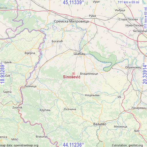
Sinošević GPS coordinates[2]
44° 36' 54.108" North, 19° 38' 9.636" East
| Map corner | latitude | longitude |
|---|---|---|
| Upper-left | 45.11339°, | 18.93289° |
| Center: | 44.61503°, | 19.63601° |
| Lower-right: | 44.11236°, | 20.33914° |
| Map W x H: | 111.3×111.3 km | = 69.2×69.2mi |
| max Lat: | 46.1° ⇑63.7% North |
| Sinošević: | 44.61503° |
| min Lat: | ⇓36.3% South 42.25846° |
| min Long | Sinošević | max Long |
| 18.9276° | 19.63601° | 22.77556° |
| W 18.6%⇐ | ⇒81.4% E |
Elevation
Elevation of Sinošević is 174 m = 571 ft, and this is 2.4 m = 8 ft below average elevation for this country.
| Max E: |
1421 m = 4662 ft | 27.7% |
| Avg. | 176.4 m = 579 ft | |
| Sinošević | 174 m = 571 ft | |
Min E: |
49 m = 161 ft | 72.3% |
See also: Serbia elevation on elevation.city.
Geographical zone
Sinošević is located in North temperate zone (between Tropic of Cancer and the Arctic Circle). Distance of this Northern Tropic circle is 2354.8 km =1463.2 mi to South.| Distance of | km | miles | from Sinošević |
|---|---|---|---|
| North Pole | 5046.3 | 3135.6 | to North |
| Arctic Circle | 2440.4 | 1516.4 | to North |
| Tropic Cancer | 2354.8 | 1463.2 | to South |
| Equator | 4960.7 | 3082.4 | to South |


Nearby cities:
15 places around Sinošević: (largest is in red/bold)
• Belotić
7.6 km =4.7 mi,  119°
119°
• Bogosavac
11.9 km =7.4 mi,  344°
344°
• Brdarica
12.7 km =7.9 mi, 122°
• Culjković
9.1 km =5.7 mi,  308°
308°
• Dobrić
10.7 km =6.6 mi, 335°
• Draginje
13.5 km =8.4 mi,  132°
132°
• Jevremovac
12.1 km =7.5 mi,  10°
10°
• Krivaja
8 km =5 mi,  206°
206°
• Mrovska
8.6 km =5.3 mi,  158°
158°
• Nakučani
2.9 km =1.8 mi, 121°
• Pocerski Pričinović
13.2 km =8.2 mi,  25°
25°
• Rumska
6 km =3.7 mi,  217°
217°
• Tekeriš
10.6 km =6.6 mi,  232°
232°
• Varna
7.2 km =4.5 mi, 9°
• Vladimirci
11.8 km =7.3 mi,  90°
90°
Sources, notices
• [Note1] Compared only with cities in Serbia existing in our database
• [Src1] Map data: © OpenStreetMap contributors (CC-BY-SA)
• [Src2] Other city data from geonames.org with taken over terms of usage.
• [Src3] Geographical zone / Annual Mean Temperature by Robert A. Rohde @ Wikipedia
