Culjković geodata
Culjković (Central Serbia) is a populated locality; located in Serbia in Europe/Belgrade (GMT+2) time zone. With population of 840 people, there are 328 cities with bigger population in this country. Compared to other cities in Serbia, 61.2% of cities are located further ↑North; 86.2% of cities are located further →East and 69.6% of cities have lower elevation than Culjković. Note1


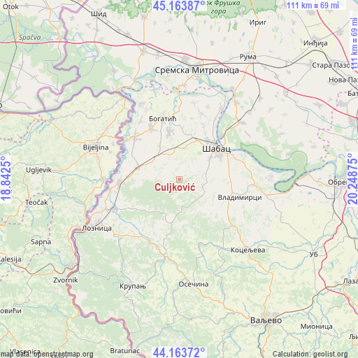
Culjković GPS coordinates[2]
44° 39' 57.42" North, 19° 32' 44.232" East
| Map corner | latitude | longitude |
|---|---|---|
| Upper-left | 45.16387°, | 18.8425° |
| Center: | 44.66595°, | 19.54562° |
| Lower-right: | 44.16372°, | 20.24875° |
| Map W x H: | 111.2×111.2 km | = 69.1×69.1mi |
| max Lat: | 46.1° ⇑61.2% North |
| Culjković: | 44.66595° |
| min Lat: | ⇓38.8% South 42.25846° |
| min Long | Culjković | max Long |
| 18.9276° | 19.54562° | 22.77556° |
| W 13.8%⇐ | ⇒86.2% E |
Elevation
Elevation of Culjković is 150 m = 492 ft, and this is 26.4 m = 87 ft below average elevation for this country.
| Max E: |
1421 m = 4662 ft | 30.4% |
| Avg. | 176.4 m = 579 ft | |
| Culjković | 150 m = 492 ft | |
Min E: |
49 m = 161 ft | 69.6% |
See also: Serbia elevation on elevation.city.
Geographical zone
Culjković is located in North temperate zone (between Tropic of Cancer and the Arctic Circle). Distance of this Northern Tropic circle is 2360.5 km =1466.7 mi to South.| Distance of | km | miles | from Culjković |
|---|---|---|---|
| North Pole | 5040.7 | 3132.1 | to North |
| Arctic Circle | 2434.8 | 1512.9 | to North |
| Tropic Cancer | 2360.5 | 1466.7 | to South |
| Equator | 4966.4 | 3086 | to South |


Nearby cities:
15 places around Culjković: (largest is in red/bold)
• Bogosavac
7 km =4.3 mi,  34°
34°
• Dobrić
4.8 km =3 mi, 33°
• Jevremovac
11.2 km =7 mi,  56°
56°
• Krivaja
13.4 km =8.3 mi,  164°
164°
• Lipolist
5 km =3.1 mi,  315°
315°
• Nakučani
12 km =7.5 mi,  126°
126°
• Petkovica
8.4 km =5.2 mi,  270°
270°
• Prnjavor
13.1 km =8.1 mi,  287°
287°
• Ribari
10.7 km =6.6 mi,  296°
296°
• Rumska
11 km =6.8 mi, 161°
• Sinošević
9.1 km =5.7 mi, 128°
• Tekeriš
12.2 km =7.6 mi,  185°
185°
• Varna
8.5 km =5.3 mi,  80°
80°
• Zminjak
11.7 km =7.3 mi,  329°
329°
• Čokešina
12.4 km =7.7 mi,  263°
263°
Sources, notices
• [Note1] Compared only with cities in Serbia existing in our database
• [Src1] Map data: © OpenStreetMap contributors (CC-BY-SA)
• [Src2] Other city data from geonames.org with taken over terms of usage.
• [Src3] Geographical zone / Annual Mean Temperature by Robert A. Rohde @ Wikipedia
