Draginje geodata
Draginje (Central Serbia) is a populated place; located in Serbia in Europe/Belgrade (GMT+2) time zone. With population of 1,888 people, there are 224 cities with bigger population in this country. Compared to other cities in Serbia, 69.2% of cities are located further ↑North; 74.8% of cities are located further →East and 79.8% of cities have lower elevation than Draginje. Note1


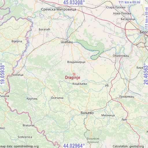
Draginje GPS coordinates[2]
44° 31' 58.872" North, 19° 45' 45" East
| Map corner | latitude | longitude |
|---|---|---|
| Upper-left | 45.03208°, | 19.05938° |
| Center: | 44.53302°, | 19.7625° |
| Lower-right: | 44.02964°, | 20.46563° |
| Map W x H: | 111.5×111.5 km | = 69.3×69.3mi |
| max Lat: | 46.1° ⇑69.2% North |
| Draginje: | 44.53302° |
| min Lat: | ⇓30.8% South 42.25846° |
| min Long | Draginje | max Long |
| 18.9276° | 19.7625° | 22.77556° |
| W 25.2%⇐ | ⇒74.8% E |
Elevation
Elevation of Draginje is 234 m = 768 ft, and this is 57.6 m = 189 ft above average elevation for this country.
| Max E: |
1421 m = 4662 ft | 20.2% |
| Draginje | 234 m 768 ft | |
| Avg. | 176.4 m = 579 ft | |
Min E: |
49 m = 161 ft | 79.8% |
See also: Serbia elevation on elevation.city.
Geographical zone
Draginje is located in North temperate zone (between Tropic of Cancer and the Arctic Circle). Distance of this Northern Tropic circle is 2345.7 km =1457.5 mi to South.| Distance of | km | miles | from Draginje |
|---|---|---|---|
| North Pole | 5055.5 | 3141.3 | to North |
| Arctic Circle | 2449.6 | 1522.1 | to North |
| Tropic Cancer | 2345.7 | 1457.5 | to South |
| Equator | 4951.6 | 3076.8 | to South |


Nearby cities:
15 places around Draginje: (largest is in red/bold)
• Belotić
6.3 km =3.9 mi,  327°
327°
• Brdarica
2.4 km =1.5 mi,  17°
17°
• Bukor
15.7 km =9.8 mi,  254°
254°
• Jelenča
21.7 km =13.5 mi,  354°
354°
• Kamenica
21.4 km =13.3 mi,  188°
188°
• Koceljeva
7.7 km =4.8 mi,  149°
149°
• Krivaja
13.7 km =8.5 mi,  278°
278°
• Mrovska
7 km =4.3 mi, 278°
• Nakučani
10.7 km =6.6 mi,  315°
315°
• Pocerski Pričinović
21.5 km =13.4 mi, 348°
• Rumska
14.4 km =8.9 mi,  287°
287°
• Sinošević
13.5 km =8.4 mi,  312°
312°
• Tekeriš
18.6 km =11.6 mi, 278°
• Varna
18.5 km =11.5 mi, 331°
• Vladimirci
9.3 km =5.8 mi,  11°
11°
Sources, notices
• [Note1] Compared only with cities in Serbia existing in our database
• [Src1] Map data: © OpenStreetMap contributors (CC-BY-SA)
• [Src2] Other city data from geonames.org with taken over terms of usage.
• [Src3] Geographical zone / Annual Mean Temperature by Robert A. Rohde @ Wikipedia
