Brdarica geodata
Brdarica (Central Serbia) is a populated place; located in Serbia in Europe/Belgrade (GMT+2) time zone. With population of 1,690 people, there are 240 cities with bigger population in this country. Compared to other cities in Serbia, 68% of cities are located further ↑North; 74.4% of cities are located further →East and 73% of cities have lower elevation than Brdarica. Note1


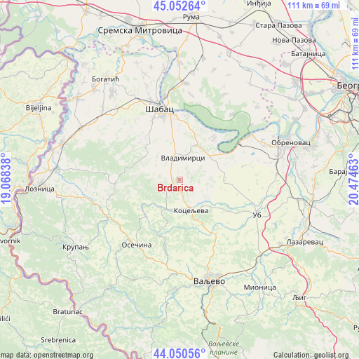
Brdarica GPS coordinates[2]
44° 33' 13.536" North, 19° 46' 17.4" East
| Map corner | latitude | longitude |
|---|---|---|
| Upper-left | 45.05264°, | 19.06838° |
| Center: | 44.55376°, | 19.7715° |
| Lower-right: | 44.05056°, | 20.47463° |
| Map W x H: | 111.4×111.4 km | = 69.2×69.2mi |
| max Lat: | 46.1° ⇑68% North |
| Brdarica: | 44.55376° |
| min Lat: | ⇓32% South 42.25846° |
| min Long | Brdarica | max Long |
| 18.9276° | 19.7715° | 22.77556° |
| W 25.6%⇐ | ⇒74.4% E |
Elevation
Elevation of Brdarica is 179 m = 587 ft, and this is 2.6 m = 9 ft above average elevation for this country.
| Max E: |
1421 m = 4662 ft | 27% |
| Brdarica | 179 m 587 ft | |
| Avg. | 176.4 m = 579 ft | |
Min E: |
49 m = 161 ft | 73% |
See also: Serbia elevation on elevation.city.
Geographical zone
Brdarica is located in North temperate zone (between Tropic of Cancer and the Arctic Circle). Distance of this Northern Tropic circle is 2348 km =1459 mi to South.| Distance of | km | miles | from Brdarica |
|---|---|---|---|
| North Pole | 5053.1 | 3139.8 | to North |
| Arctic Circle | 2447.3 | 1520.7 | to North |
| Tropic Cancer | 2348 | 1459 | to South |
| Equator | 4953.9 | 3078.2 | to South |


Nearby cities:
15 places around Brdarica: (largest is in red/bold)
• Belotić
5.1 km =3.2 mi,  306°
306°
• Bukor
17.2 km =10.7 mi,  247°
247°
• Draginje
2.4 km =1.5 mi,  197°
197°
• Jelenča
19.5 km =12.1 mi,  351°
351°
• Jevremovac
20.5 km =12.7 mi,  335°
335°
• Koceljeva
9.5 km =5.9 mi,  160°
160°
• Krivaja
14.3 km =8.9 mi,  268°
268°
• Mrovska
7.7 km =4.8 mi,  260°
260°
• Nakučani
9.8 km =6.1 mi,  302°
302°
• Pocerski Pričinović
19.4 km =12.1 mi, 344°
• Rumska
14.5 km =9 mi,  278°
278°
• Sinošević
12.7 km =7.9 mi, 302°
• Tekeriš
19.2 km =11.9 mi, 271°
• Varna
16.9 km =10.5 mi,  325°
325°
• Vladimirci
6.9 km =4.3 mi,  9°
9°
Sources, notices
• [Note1] Compared only with cities in Serbia existing in our database
• [Src1] Map data: © OpenStreetMap contributors (CC-BY-SA)
• [Src2] Other city data from geonames.org with taken over terms of usage.
• [Src3] Geographical zone / Annual Mean Temperature by Robert A. Rohde @ Wikipedia
