Prnjavor geodata
Prnjavor (Central Serbia) is a populated place; located in Serbia in Europe/Belgrade (GMT+2) time zone. With population of 4,892 people, there are 95 cities with bigger population in this country. Compared to other cities in Serbia, 59.2% of cities are located further ↑North; 92.5% of cities are located further →East and 54% of cities have lower elevation than Prnjavor. Note1


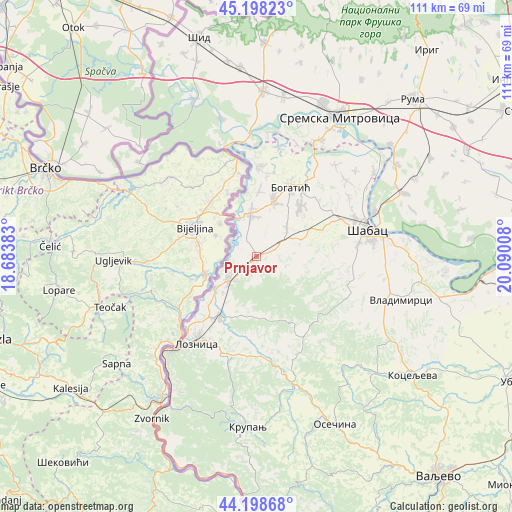
Prnjavor GPS coordinates[2]
44° 42' 2.196" North, 19° 23' 13.02" East
| Map corner | latitude | longitude |
|---|---|---|
| Upper-left | 45.19823°, | 18.68383° |
| Center: | 44.70061°, | 19.38695° |
| Lower-right: | 44.19868°, | 20.09008° |
| Map W x H: | 111.1×111.1 km | = 69×69mi |
| max Lat: | 46.1° ⇑59.2% North |
| Prnjavor: | 44.70061° |
| min Lat: | ⇓40.8% South 42.25846° |
| min Long | Prnjavor | max Long |
| 18.9276° | 19.38695° | 22.77556° |
| W 7.5%⇐ | ⇒92.5% E |
Elevation
Elevation of Prnjavor is 95 m = 312 ft, and this is 81.4 m = 267 ft below average elevation for this country.
| Max E: |
1421 m = 4662 ft | 46% |
| Avg. | 176.4 m = 579 ft | |
| Prnjavor | 95 m = 312 ft | |
Min E: |
49 m = 161 ft | 54% |
See also: Serbia elevation on elevation.city.
Geographical zone
Prnjavor is located in North temperate zone (between Tropic of Cancer and the Arctic Circle). Distance of this Northern Tropic circle is 2364.3 km =1469.1 mi to South.| Distance of | km | miles | from Prnjavor |
|---|---|---|---|
| North Pole | 5036.8 | 3129.7 | to North |
| Arctic Circle | 2430.9 | 1510.5 | to North |
| Tropic Cancer | 2364.3 | 1469.1 | to South |
| Equator | 4970.2 | 3088.3 | to South |


Nearby cities:
15 places around Prnjavor: (largest is in red/bold)
• Badovinci
9.5 km =5.9 mi,  352°
352°
• Culjković
13.1 km =8.1 mi,  107°
107°
• Donji Dobrić
10.8 km =6.7 mi,  204°
204°
• Gornji Dobrić
14.5 km =9 mi,  205°
205°
• Jadranska Lešnica
11.8 km =7.3 mi,  193°
193°
• Joševa
12.7 km =7.9 mi,  171°
171°
• Klenje
12.5 km =7.8 mi,  17°
17°
• Lešnica
8.1 km =5 mi,  228°
228°
• Lipolist
9 km =5.6 mi,  91°
91°
• Novo Selo
4.7 km =2.9 mi,  224°
224°
• Petkovica
5.6 km =3.5 mi,  132°
132°
• Ribari
3.1 km =1.9 mi,  71°
71°
• Salaš Crnobarski
14.2 km =8.8 mi,  2°
2°
• Zminjak
9.1 km =5.7 mi,  46°
46°
• Čokešina
5.3 km =3.3 mi,  177°
177°
Sources, notices
• [Note1] Compared only with cities in Serbia existing in our database
• [Src1] Map data: © OpenStreetMap contributors (CC-BY-SA)
• [Src2] Other city data from geonames.org with taken over terms of usage.
• [Src3] Geographical zone / Annual Mean Temperature by Robert A. Rohde @ Wikipedia
