Zminjak geodata
Zminjak (Central Serbia) is a populated place; located in Serbia in Europe/Belgrade (GMT+2) time zone. With population of 1,536 people, there are 260 cities with bigger population in this country. Compared to other cities in Serbia, 56.2% of cities are located further ↑North; 89.3% of cities are located further →East and 53.1% of cities have higher elevation than Zminjak. Note1


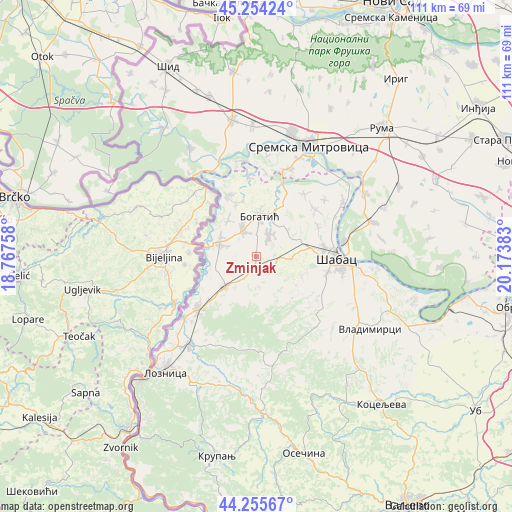
Zminjak GPS coordinates[2]
44° 45' 25.596" North, 19° 28' 14.52" East
| Map corner | latitude | longitude |
|---|---|---|
| Upper-left | 45.25424°, | 18.76758° |
| Center: | 44.75711°, | 19.4707° |
| Lower-right: | 44.25567°, | 20.17383° |
| Map W x H: | 111×111 km | = 69×69mi |
| max Lat: | 46.1° ⇑56.2% North |
| Zminjak: | 44.75711° |
| min Lat: | ⇓43.8% South 42.25846° |
| min Long | Zminjak | max Long |
| 18.9276° | 19.4707° | 22.77556° |
| W 10.7%⇐ | ⇒89.3% E |
Elevation
Elevation of Zminjak is 87 m = 285 ft, and this is 89.4 m = 293 ft below average elevation for this country.
| Max E: |
1421 m = 4662 ft | 53.1% |
| Avg. | 176.4 m = 579 ft | |
| Zminjak | 87 m = 285 ft | |
Min E: |
49 m = 161 ft | 46.9% |
See also: Serbia elevation on elevation.city.
Geographical zone
Zminjak is located in North temperate zone (between Tropic of Cancer and the Arctic Circle). Distance of this Northern Tropic circle is 2370.6 km =1473 mi to South.| Distance of | km | miles | from Zminjak |
|---|---|---|---|
| North Pole | 5030.5 | 3125.8 | to North |
| Arctic Circle | 2424.6 | 1506.6 | to North |
| Tropic Cancer | 2370.6 | 1473 | to South |
| Equator | 4976.5 | 3092.3 | to South |


Nearby cities:
15 places around Zminjak: (largest is in red/bold)
• Badovinci
8.4 km =5.2 mi,  291°
291°
• Belotić
9.1 km =5.7 mi,  42°
42°
• Bogatić
9 km =5.6 mi,  4°
4°
• Bogosavac
10.8 km =6.7 mi,  113°
113°
• Culjković
11.7 km =7.3 mi,  149°
149°
• Dobrić
10.5 km =6.5 mi,  125°
125°
• Dublje
5.8 km =3.6 mi,  31°
31°
• Klenje
6.3 km =3.9 mi,  333°
333°
• Lipolist
7 km =4.3 mi,  160°
160°
• Metković
12.5 km =7.8 mi, 28°
• Petkovica
10.4 km =6.5 mi,  193°
193°
• Prnjavor
9.1 km =5.7 mi,  226°
226°
• Ribari
6.4 km =4 mi,  214°
214°
• Salaš Crnobarski
10 km =6.2 mi,  322°
322°
• Štitar
10.7 km =6.6 mi,  67°
67°
Sources, notices
• [Note1] Compared only with cities in Serbia existing in our database
• [Src1] Map data: © OpenStreetMap contributors (CC-BY-SA)
• [Src2] Other city data from geonames.org with taken over terms of usage.
• [Src3] Geographical zone / Annual Mean Temperature by Robert A. Rohde @ Wikipedia
