Bač geodata
Bač (Vojvodina) is a seat of a third-order administrative division; located in Serbia in Europe/Belgrade (GMT+2) time zone. In our database, there are 365 cities with bigger population. Compared to other cities in Serbia, 81.4% of cities are located further ↓South; 96.8% of cities are located further →East and 63.3% of cities have higher elevation than Bač. Note1


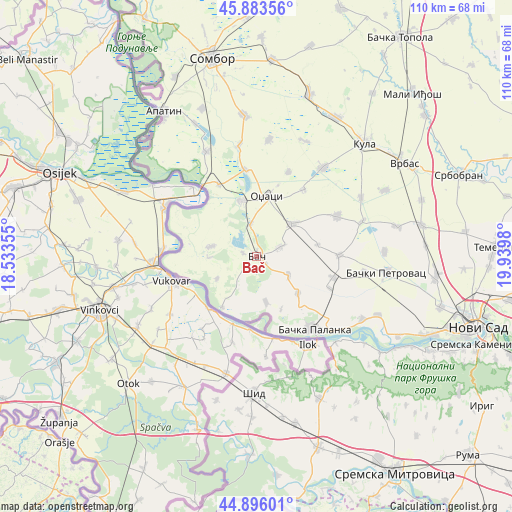
Bač GPS coordinates[2]
45° 23' 30.984" North, 19° 14' 12.012" East
| Map corner | latitude | longitude |
|---|---|---|
| Upper-left | 45.88356°, | 18.53355° |
| Center: | 45.39194°, | 19.23667° |
| Lower-right: | 44.89601°, | 19.9398° |
| Map W x H: | 109.8×109.8 km | = 68.2×68.2mi |
| max Lat: | 46.1° ⇑18.6% North |
| Bač: | 45.39194° |
| min Lat: | ⇓81.4% South 42.25846° |
| min Long | Bač | max Long |
| 18.9276° | 19.23667° | 22.77556° |
| W 3.2%⇐ | ⇒96.8% E |
Elevation
Elevation of Bač is 81 m = 266 ft, and this is 95.4 m = 313 ft below average elevation for this country.
| Max E: |
1421 m = 4662 ft | 63.3% |
| Avg. | 176.4 m = 579 ft | |
| Bač | 81 m = 266 ft | |
Min E: |
49 m = 161 ft | 36.7% |
See also: Serbia elevation on elevation.city.
Geographical zone
Bač is located in North temperate zone (between Tropic of Cancer and the Arctic Circle). Distance of this North polar circle is 2354.1 km =1462.8 mi to North.| Distance of | km | miles | from Bač |
|---|---|---|---|
| North Pole | 4960 | 3082 | to North |
| Arctic Circle | 2354.1 | 1462.8 | to North |
| Tropic Cancer | 2441.2 | 1516.9 | to South |
| Equator | 5047.1 | 3136.1 | to South |


Nearby cities:
15 places around Bač: (largest is in red/bold)
• Bačka Palanka
20.2 km =12.6 mi,  141°
141°
• Bački Petrovac
27.9 km =17.3 mi,  97°
97°
• Bogojevo
17.5 km =10.9 mi,  331°
331°
• Despotovo
23.8 km =14.8 mi,  71°
71°
• Doroslovo
24.2 km =15 mi,  351°
351°
• Gložan
28.8 km =17.9 mi,  115°
115°
• Kula
33 km =20.5 mi,  43°
43°
• Kulpin
27.5 km =17.1 mi,  87°
87°
• Maglić
23.3 km =14.5 mi, 98°
• Obrovac
11.9 km =7.4 mi,  131°
131°
• Odžaci
12.9 km =8 mi,  8°
8°
• Ravno Selo
30.7 km =19.1 mi,  77°
77°
• Sonta
25 km =15.5 mi, 334°
• Čelarevo
26.3 km =16.3 mi, 121°
• Šid
29.3 km =18.2 mi,  181°
181°
Sources, notices
• [Note1] Compared only with cities in Serbia existing in our database
• [Src1] Map data: © OpenStreetMap contributors (CC-BY-SA)
• [Src2] Other city data from geonames.org with taken over terms of usage.
• [Src3] Geographical zone / Annual Mean Temperature by Robert A. Rohde @ Wikipedia
