Dublje geodata
Dublje (Central Serbia) is a populated place; located in Serbia in Europe/Belgrade (GMT+2) time zone. With population of 3,558 people, there are 125 cities with bigger population in this country. Compared to other cities in Serbia, 53.1% of cities are located further ↑North; 87.8% of cities are located further →East and 56.5% of cities have higher elevation than Dublje. Note1


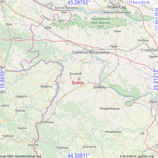
Dublje GPS coordinates[2]
44° 48' 4.212" North, 19° 30' 32.472" East
| Map corner | latitude | longitude |
|---|---|---|
| Upper-left | 45.29792°, | 18.8059° |
| Center: | 44.80117°, | 19.50902° |
| Lower-right: | 44.30011°, | 20.21215° |
| Map W x H: | 110.9×110.9 km | = 68.9×68.9mi |
| max Lat: | 46.1° ⇑53.1% North |
| Dublje: | 44.80117° |
| min Lat: | ⇓46.9% South 42.25846° |
| min Long | Dublje | max Long |
| 18.9276° | 19.50902° | 22.77556° |
| W 12.2%⇐ | ⇒87.8% E |
Elevation
Elevation of Dublje is 84 m = 276 ft, and this is 92.4 m = 303 ft below average elevation for this country.
| Max E: |
1421 m = 4662 ft | 56.5% |
| Avg. | 176.4 m = 579 ft | |
| Dublje | 84 m = 276 ft | |
Min E: |
49 m = 161 ft | 43.5% |
See also: Serbia elevation on elevation.city.
Geographical zone
Dublje is located in North temperate zone (between Tropic of Cancer and the Arctic Circle). Distance of this Northern Tropic circle is 2375.5 km =1476.1 mi to South.| Distance of | km | miles | from Dublje |
|---|---|---|---|
| North Pole | 5025.6 | 3122.8 | to North |
| Arctic Circle | 2419.8 | 1503.6 | to North |
| Tropic Cancer | 2375.5 | 1476.1 | to South |
| Equator | 4981.4 | 3095.3 | to South |


Nearby cities:
15 places around Dublje: (largest is in red/bold)
• Badovinci
11 km =6.8 mi,  260°
260°
• Belotić
3.6 km =2.2 mi,  58°
58°
• Bogatić
4.6 km =2.9 mi,  330°
330°
• Bogosavac
11.5 km =7.1 mi,  143°
143°
• Glogovac
10.1 km =6.3 mi,  313°
313°
• Glušci
10.4 km =6.5 mi,  17°
17°
• Klenje
5.9 km =3.7 mi,  277°
277°
• Lipolist
11.5 km =7.1 mi,  183°
183°
• Majur
12 km =7.5 mi,  106°
106°
• Metković
6.8 km =4.2 mi,  25°
25°
• Salaš Crnobarski
9.5 km =5.9 mi,  288°
288°
• Tabanović
10.6 km =6.6 mi,  78°
78°
• Uzveće
11.4 km =7.1 mi,  40°
40°
• Zminjak
5.8 km =3.6 mi,  211°
211°
• Štitar
6.9 km =4.3 mi,  96°
96°
Sources, notices
• [Note1] Compared only with cities in Serbia existing in our database
• [Src1] Map data: © OpenStreetMap contributors (CC-BY-SA)
• [Src2] Other city data from geonames.org with taken over terms of usage.
• [Src3] Geographical zone / Annual Mean Temperature by Robert A. Rohde @ Wikipedia
