Žitište geodata
Žitište (Vojvodina) is a seat of a third-order administrative division; located in Serbia in Europe/Belgrade (GMT+2) time zone. With population of 3,060 people, there are 148 cities with bigger population in this country. Compared to other cities in Serbia, 85% of cities are located further ↓South; 60.8% of cities are located further ←West and 78.9% of cities have higher elevation than Žitište. Note1


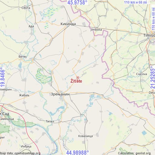
Žitište GPS coordinates[2]
45° 29' 6" North, 20° 32' 58.992" East
| Map corner | latitude | longitude |
|---|---|---|
| Upper-left | 45.9758°, | 19.8466° |
| Center: | 45.485°, | 20.54972° |
| Lower-right: | 44.98988°, | 21.25285° |
| Map W x H: | 109.6×109.6 km | = 68.1×68.1mi |
| max Lat: | 46.1° ⇑15% North |
| Žitište: | 45.485° |
| min Lat: | ⇓85% South 42.25846° |
| min Long | Žitište | max Long |
| 18.9276° | 20.54972° | 22.77556° |
| W 60.8%⇐ | ⇒39.2% E |
Elevation
Elevation of Žitište is 78 m = 256 ft, and this is 98.4 m = 323 ft below average elevation for this country.
| Max E: |
1421 m = 4662 ft | 78.9% |
| Avg. | 176.4 m = 579 ft | |
| Žitište | 78 m = 256 ft | |
Min E: |
49 m = 161 ft | 21.1% |
See also: Serbia elevation on elevation.city.
Geographical zone
Žitište is located in North temperate zone (between Tropic of Cancer and the Arctic Circle). Distance of this North polar circle is 2343.7 km =1456.3 mi to North.| Distance of | km | miles | from Žitište |
|---|---|---|---|
| North Pole | 4949.6 | 3075.5 | to North |
| Arctic Circle | 2343.7 | 1456.3 | to North |
| Tropic Cancer | 2451.5 | 1523.3 | to South |
| Equator | 5057.5 | 3142.6 | to South |


Nearby cities:
15 places around Žitište: (largest is in red/bold)
• Banatski Despotovac
16 km =9.9 mi,  145°
145°
• Banatski Dvor
4.8 km =3 mi,  321°
321°
• Banatsko Karađorđevo
11.4 km =7.1 mi,  5°
5°
• Jankov Most
8.8 km =5.5 mi,  262°
262°
• Klek
8.8 km =5.5 mi,  217°
217°
• Krajišnik
14.5 km =9 mi,  104°
104°
• Lazarevo
10.7 km =6.6 mi,  184°
184°
• Mihajlovo
10.6 km =6.6 mi, 261°
• Novi Itebej
14.3 km =8.9 mi,  54°
54°
• Ravni Topolovac
3.1 km =1.9 mi, 150°
• Srpski Itebej
15.7 km =9.8 mi, 54°
• Sutjeska
16.1 km =10 mi,  134°
134°
• Torak
5.4 km =3.4 mi,  59°
59°
• Torda
13.1 km =8.1 mi,  327°
327°
• Čestereg
8.8 km =5.5 mi,  350°
350°
Sources, notices
• [Note1] Compared only with cities in Serbia existing in our database
• [Src1] Map data: © OpenStreetMap contributors (CC-BY-SA)
• [Src2] Other city data from geonames.org with taken over terms of usage.
• [Src3] Geographical zone / Annual Mean Temperature by Robert A. Rohde @ Wikipedia
