Lazarevo geodata
Lazarevo (Vojvodina) is a populated place; located in Serbia in Europe/Belgrade (GMT+2) time zone. With population of 3,480 people, there are 128 cities with bigger population in this country. Compared to other cities in Serbia, 81.2% of cities are located further ↓South; 60.5% of cities are located further ←West and 90.7% of cities have higher elevation than Lazarevo. Note1


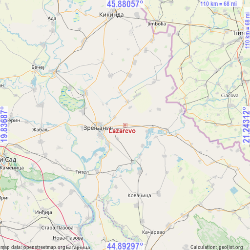
Lazarevo GPS coordinates[2]
45° 23' 20.148" North, 20° 32' 23.964" East
| Map corner | latitude | longitude |
|---|---|---|
| Upper-left | 45.88057°, | 19.83687° |
| Center: | 45.38893°, | 20.53999° |
| Lower-right: | 44.89297°, | 21.24312° |
| Map W x H: | 109.8×109.8 km | = 68.2×68.2mi |
| max Lat: | 46.1° ⇑18.8% North |
| Lazarevo: | 45.38893° |
| min Lat: | ⇓81.2% South 42.25846° |
| min Long | Lazarevo | max Long |
| 18.9276° | 20.53999° | 22.77556° |
| W 60.5%⇐ | ⇒39.5% E |
Elevation
Elevation of Lazarevo is 76 m = 249 ft, and this is 100.4 m = 329 ft below average elevation for this country.
| Max E: |
1421 m = 4662 ft | 90.7% |
| Avg. | 176.4 m = 579 ft | |
| Lazarevo | 76 m = 249 ft | |
Min E: |
49 m = 161 ft | 9.3% |
See also: Serbia elevation on elevation.city.
Geographical zone
Lazarevo is located in North temperate zone (between Tropic of Cancer and the Arctic Circle). Distance of this North polar circle is 2354.4 km =1463 mi to North.| Distance of | km | miles | from Lazarevo |
|---|---|---|---|
| North Pole | 4960.3 | 3082.2 | to North |
| Arctic Circle | 2354.4 | 1463 | to North |
| Tropic Cancer | 2440.9 | 1516.7 | to South |
| Equator | 5046.8 | 3135.9 | to South |


Nearby cities:
15 places around Lazarevo: (largest is in red/bold)
• Banatski Despotovac
10 km =6.2 mi,  104°
104°
• Botoš
11.6 km =7.2 mi,  140°
140°
• Ečka
10.5 km =6.5 mi,  226°
226°
• Jankov Most
12.4 km =7.7 mi,  320°
320°
• Klek
6 km =3.7 mi,  308°
308°
• Lukino Selo
13.1 km =8.1 mi,  222°
222°
• Lukićevo
6.5 km =4 mi,  209°
209°
• Mihajlovo
13.3 km =8.3 mi, 313°
• Neuzina
14.5 km =9 mi,  109°
109°
• Ravni Topolovac
8.3 km =5.2 mi,  16°
16°
• Stajićevo
12.2 km =7.6 mi, 211°
• Sutjeska
12.2 km =7.6 mi,  93°
93°
• Torak
14.4 km =8.9 mi, 21°
• Zrenjanin
12.4 km =7.7 mi,  267°
267°
• Žitište
10.7 km =6.6 mi,  4°
4°
Sources, notices
• [Note1] Compared only with cities in Serbia existing in our database
• [Src1] Map data: © OpenStreetMap contributors (CC-BY-SA)
• [Src2] Other city data from geonames.org with taken over terms of usage.
• [Src3] Geographical zone / Annual Mean Temperature by Robert A. Rohde @ Wikipedia
