Stajićevo geodata
Stajićevo (Vojvodina) is a populated place; located in Serbia in Europe/Belgrade (GMT+2) time zone. With population of 1,993 people, there are 218 cities with bigger population in this country. Compared to other cities in Serbia, 76.4% of cities are located further ↓South; 55.6% of cities are located further ←West and 78.9% of cities have higher elevation than Stajićevo. Note1


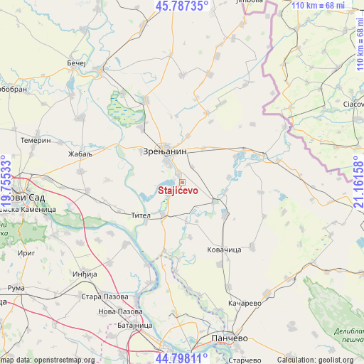
Stajićevo GPS coordinates[2]
45° 17' 41.604" North, 20° 27' 30.42" East
| Map corner | latitude | longitude |
|---|---|---|
| Upper-left | 45.78735°, | 19.75533° |
| Center: | 45.29489°, | 20.45845° |
| Lower-right: | 44.79811°, | 21.16158° |
| Map W x H: | 110×110 km | = 68.4×68.4mi |
| max Lat: | 46.1° ⇑23.6% North |
| Stajićevo: | 45.29489° |
| min Lat: | ⇓76.4% South 42.25846° |
| min Long | Stajićevo | max Long |
| 18.9276° | 20.45845° | 22.77556° |
| W 55.6%⇐ | ⇒44.4% E |
Elevation
Elevation of Stajićevo is 78 m = 256 ft, and this is 98.4 m = 323 ft below average elevation for this country.
| Max E: |
1421 m = 4662 ft | 78.9% |
| Avg. | 176.4 m = 579 ft | |
| Stajićevo | 78 m = 256 ft | |
Min E: |
49 m = 161 ft | 21.1% |
See also: Serbia elevation on elevation.city.
Geographical zone
Stajićevo is located in North temperate zone (between Tropic of Cancer and the Arctic Circle). Distance of this North polar circle is 2364.9 km =1469.5 mi to North.| Distance of | km | miles | from Stajićevo |
|---|---|---|---|
| North Pole | 4970.7 | 3088.6 | to North |
| Arctic Circle | 2364.9 | 1469.5 | to North |
| Tropic Cancer | 2430.4 | 1510.2 | to South |
| Equator | 5036.3 | 3129.4 | to South |


Nearby cities:
15 places around Stajićevo: (largest is in red/bold)
• Aradac
15.7 km =9.8 mi,  308°
308°
• Belo Blato
7 km =4.3 mi,  249°
249°
• Botoš
13.9 km =8.6 mi,  83°
83°
• Ečka
3.4 km =2.1 mi,  338°
338°
• Farkaždin
11.5 km =7.1 mi,  174°
174°
• Idvor
12.6 km =7.8 mi,  159°
159°
• Klek
14.3 km =8.9 mi,  6°
6°
• Knićanin
16.2 km =10.1 mi,  222°
222°
• Lazarevo
12.2 km =7.6 mi,  31°
31°
• Lukino Selo
2.6 km =1.6 mi,  288°
288°
• Lukićevo
5.8 km =3.6 mi, 33°
• Orlovat
11.3 km =7 mi,  121°
121°
• Perlez
11.4 km =7.1 mi,  211°
211°
• Tomaševac
13.2 km =8.2 mi,  102°
102°
• Zrenjanin
11.5 km =7.1 mi,  328°
328°
Sources, notices
• [Note1] Compared only with cities in Serbia existing in our database
• [Src1] Map data: © OpenStreetMap contributors (CC-BY-SA)
• [Src2] Other city data from geonames.org with taken over terms of usage.
• [Src3] Geographical zone / Annual Mean Temperature by Robert A. Rohde @ Wikipedia
