Lukićevo geodata
Lukićevo (Vojvodina) is a populated place; located in Serbia in Europe/Belgrade (GMT+2) time zone. With population of 2,186 people, there are 199 cities with bigger population in this country. Compared to other cities in Serbia, 78.5% of cities are located further ↓South; 58.5% of cities are located further ←West and 67.1% of cities have higher elevation than Lukićevo. Note1


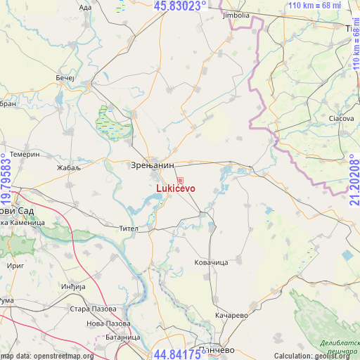
Lukićevo GPS coordinates[2]
45° 20' 17.34" North, 20° 29' 56.22" East
| Map corner | latitude | longitude |
|---|---|---|
| Upper-left | 45.83023°, | 19.79583° |
| Center: | 45.33815°, | 20.49895° |
| Lower-right: | 44.84175°, | 21.20208° |
| Map W x H: | 109.9×109.9 km | = 68.3×68.3mi |
| max Lat: | 46.1° ⇑21.5% North |
| Lukićevo: | 45.33815° |
| min Lat: | ⇓78.5% South 42.25846° |
| min Long | Lukićevo | max Long |
| 18.9276° | 20.49895° | 22.77556° |
| W 58.5%⇐ | ⇒41.5% E |
Elevation
Elevation of Lukićevo is 80 m = 262 ft, and this is 96.4 m = 316 ft below average elevation for this country.
| Max E: |
1421 m = 4662 ft | 67.1% |
| Avg. | 176.4 m = 579 ft | |
| Lukićevo | 80 m = 262 ft | |
Min E: |
49 m = 161 ft | 32.9% |
See also: Serbia elevation on elevation.city.
Geographical zone
Lukićevo is located in North temperate zone (between Tropic of Cancer and the Arctic Circle). Distance of this North polar circle is 2360 km =1466.4 mi to North.| Distance of | km | miles | from Lukićevo |
|---|---|---|---|
| North Pole | 4965.9 | 3085.7 | to North |
| Arctic Circle | 2360 | 1466.4 | to North |
| Tropic Cancer | 2435.2 | 1513.2 | to South |
| Equator | 5041.1 | 3132.4 | to South |


Nearby cities:
15 places around Lukićevo: (largest is in red/bold)
• Banatski Despotovac
13.3 km =8.3 mi,  76°
76°
• Belo Blato
12.1 km =7.5 mi,  233°
233°
• Botoš
11.2 km =7 mi,  107°
107°
• Ečka
4.7 km =2.9 mi,  249°
249°
• Jankov Most
15.9 km =9.9 mi,  342°
342°
• Klek
9.5 km =5.9 mi,  351°
351°
• Lazarevo
6.5 km =4 mi,  29°
29°
• Lukino Selo
6.9 km =4.3 mi,  235°
235°
• Mihajlovo
16.1 km =10 mi, 336°
• Orlovat
12.5 km =7.8 mi,  149°
149°
• Ravni Topolovac
14.7 km =9.1 mi,  21°
21°
• Stajićevo
5.8 km =3.6 mi,  213°
213°
• Sutjeska
16.2 km =10.1 mi,  72°
72°
• Tomaševac
12.4 km =7.7 mi,  128°
128°
• Zrenjanin
10.4 km =6.5 mi,  298°
298°
Sources, notices
• [Note1] Compared only with cities in Serbia existing in our database
• [Src1] Map data: © OpenStreetMap contributors (CC-BY-SA)
• [Src2] Other city data from geonames.org with taken over terms of usage.
• [Src3] Geographical zone / Annual Mean Temperature by Robert A. Rohde @ Wikipedia
