Barajevo geodata
Barajevo (Central Serbia) is a seat of a third-order administrative division; located in Serbia in Europe/Belgrade (GMT+2) time zone. In our database, there are 365 cities with bigger population. Compared to other cities in Serbia, 66.9% of cities are located further ↑North; 52.8% of cities are located further ←West and 68.3% of cities have lower elevation than Barajevo. Note1
Administrative division(s):
- Level 1: Central Serbia
- Level 2: Belgrade
- Level 3: Opština Beograd-Barajevo


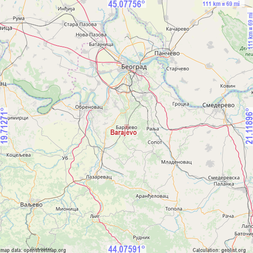
Barajevo GPS coordinates[2]
44° 34' 44.004" North, 20° 24' 56.988" East
| Map corner | latitude | longitude |
|---|---|---|
| Upper-left | 45.07756°, | 19.71271° |
| Center: | 44.57889°, | 20.41583° |
| Lower-right: | 44.07591°, | 21.11896° |
| Map W x H: | 111.4×111.4 km | = 69.2×69.2mi |
| max Lat: | 46.1° ⇑66.9% North |
| Barajevo: | 44.57889° |
| min Lat: | ⇓33.1% South 42.25846° |
| min Long | Barajevo | max Long |
| 18.9276° | 20.41583° | 22.77556° |
| W 52.8%⇐ | ⇒47.2% E |
Elevation
Elevation of Barajevo is 142 m = 466 ft, and this is 34.4 m = 113 ft below average elevation for this country.
| Max E: |
1421 m = 4662 ft | 31.7% |
| Avg. | 176.4 m = 579 ft | |
| Barajevo | 142 m = 466 ft | |
Min E: |
49 m = 161 ft | 68.3% |
See also: Serbia elevation on elevation.city.
Geographical zone
Barajevo is located in North temperate zone (between Tropic of Cancer and the Arctic Circle). Distance of this Northern Tropic circle is 2350.8 km =1460.7 mi to South.| Distance of | km | miles | from Barajevo |
|---|---|---|---|
| North Pole | 5050.4 | 3138.2 | to North |
| Arctic Circle | 2444.5 | 1518.9 | to North |
| Tropic Cancer | 2350.8 | 1460.7 | to South |
| Equator | 4956.7 | 3079.9 | to South |


Nearby cities:
15 places around Barajevo: (largest is in red/bold)
• Barič
14.7 km =9.1 mi,  302°
302°
• Boljevci
22.1 km =13.7 mi,  316°
316°
• Mala Moštanica
10.9 km =6.8 mi,  307°
307°
• Obrenovac
19 km =11.8 mi, 296°
• Ostružnica
18.3 km =11.4 mi,  335°
335°
• Rakovica
18.2 km =11.3 mi,  6°
6°
• Rušanj
12.1 km =7.5 mi, 12°
• Sopot
14.1 km =8.8 mi,  117°
117°
• Sremčica
11 km =6.8 mi,  350°
350°
• Stepojevac
12.1 km =7.5 mi,  232°
232°
• Stubline
22.3 km =13.9 mi,  268°
268°
• Umka
14.1 km =8.8 mi, 321°
• Velika Moštanica
10.7 km =6.6 mi,  332°
332°
• Vranić
7.4 km =4.6 mi,  290°
290°
• Zvečka
21 km =13 mi, 288°
Sources, notices
• [Note1] Compared only with cities in Serbia existing in our database
• [Src1] Map data: © OpenStreetMap contributors (CC-BY-SA)
• [Src2] Other city data from geonames.org with taken over terms of usage.
• [Src3] Geographical zone / Annual Mean Temperature by Robert A. Rohde @ Wikipedia
