Uzdin geodata
Uzdin (Vojvodina) is a populated place; located in Serbia in Europe/Belgrade (GMT+2) time zone. With population of 3,885 people, there are 114 cities with bigger population in this country. Compared to other cities in Serbia, 69.8% of cities are located further ↓South; 64.9% of cities are located further ←West and 84.8% of cities have higher elevation than Uzdin. Note1


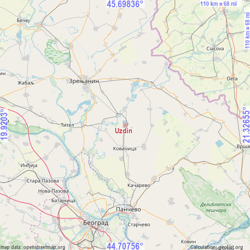
Uzdin GPS coordinates[2]
45° 12' 18.432" North, 20° 37' 24.312" East
| Map corner | latitude | longitude |
|---|---|---|
| Upper-left | 45.69836°, | 19.9203° |
| Center: | 45.20512°, | 20.62342° |
| Lower-right: | 44.70756°, | 21.32655° |
| Map W x H: | 110.2×110.2 km | = 68.5×68.5mi |
| max Lat: | 46.1° ⇑30.2% North |
| Uzdin: | 45.20512° |
| min Lat: | ⇓69.8% South 42.25846° |
| min Long | Uzdin | max Long |
| 18.9276° | 20.62342° | 22.77556° |
| W 64.9%⇐ | ⇒35.1% E |
Elevation
Elevation of Uzdin is 77 m = 253 ft, and this is 99.4 m = 326 ft below average elevation for this country.
| Max E: |
1421 m = 4662 ft | 84.8% |
| Avg. | 176.4 m = 579 ft | |
| Uzdin | 77 m = 253 ft | |
Min E: |
49 m = 161 ft | 15.2% |
See also: Serbia elevation on elevation.city.
Geographical zone
Uzdin is located in North temperate zone (between Tropic of Cancer and the Arctic Circle). Distance of this North polar circle is 2374.8 km =1475.6 mi to North.| Distance of | km | miles | from Uzdin |
|---|---|---|---|
| North Pole | 4980.7 | 3094.9 | to North |
| Arctic Circle | 2374.8 | 1475.6 | to North |
| Tropic Cancer | 2420.4 | 1504 | to South |
| Equator | 5026.3 | 3123.2 | to South |


Nearby cities:
15 places around Uzdin: (largest is in red/bold)
• Banatska Dubica
17.7 km =11 mi,  65°
65°
• Botoš
11.5 km =7.1 mi,  4°
4°
• Debeljača
15 km =9.3 mi,  186°
186°
• Farkaždin
11.9 km =7.4 mi,  262°
262°
• Idvor
8.7 km =5.4 mi, 258°
• Jarkovac
12.9 km =8 mi,  56°
56°
• Kovačica
10.4 km =6.5 mi,  180°
180°
• Lukićevo
17.7 km =11 mi,  326°
326°
• Neuzina
17.1 km =10.6 mi,  24°
24°
• Orlovat
5.3 km =3.3 mi,  320°
320°
• Padina
12.6 km =7.8 mi,  138°
138°
• Sakule
12.6 km =7.8 mi,  238°
238°
• Samoš
11.8 km =7.3 mi,  91°
91°
• Stajićevo
16.3 km =10.1 mi,  307°
307°
• Tomaševac
7.1 km =4.4 mi,  359°
359°
Sources, notices
• [Note1] Compared only with cities in Serbia existing in our database
• [Src1] Map data: © OpenStreetMap contributors (CC-BY-SA)
• [Src2] Other city data from geonames.org with taken over terms of usage.
• [Src3] Geographical zone / Annual Mean Temperature by Robert A. Rohde @ Wikipedia
