Vikhorevka geodata
Vikhorevka (Irkutsk Oblast) is a populated place; located in Russia in Asia/Irkutsk (GMT+8) time zone. With population of 22,500 people, there are 803 cities with bigger population in this country. Compared to other cities in Russia, 68.2% of cities are located further ↓South; 88.5% of cities are located further ←West and 87.2% of cities have lower elevation than Vikhorevka. Note1


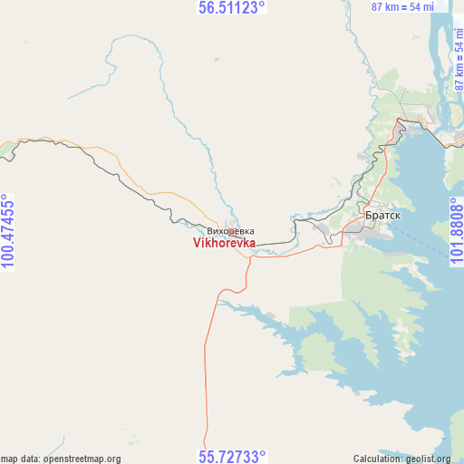
Vikhorevka GPS coordinates[2]
56° 7' 16.608" North, 101° 10' 39.612" East
| Map corner | latitude | longitude |
|---|---|---|
| Upper-left | 56.51123°, | 100.47455° |
| Center: | 56.12128°, | 101.17767° |
| Lower-right: | 55.72733°, | 101.8808° |
| Map W x H: | 87.2×87.2 km | = 54.2×54.2mi |
| max Lat: | 73.50819° ⇑31.8% North |
| Vikhorevka: | 56.12128° |
| min Lat: | ⇓68.2% South 41.28413° |
| min Long | Vikhorevka | max Long |
| -179.12198° | 101.17767° | 179.35046° |
| W 88.5%⇐ | ⇒11.5% E |
Elevation
Elevation of Vikhorevka is 375 m = 1230 ft, and this is 172.4 m = 566 ft above average elevation for this country.
| Max E: |
2518 m = 8261 ft | 12.8% |
| Vikhorevka | 375 m 1230 ft | |
| Avg. | 202.6 m = 665 ft | |
Min E: |
-28 m = -92 ft | 87.2% |
See also: Russia elevation on elevation.city.
Geographical zone
Vikhorevka is located in North temperate zone (between Tropic of Cancer and the Arctic Circle). Distance of this North polar circle is 1161.1 km =721.5 mi to North.| Distance of | km | miles | from Vikhorevka |
|---|---|---|---|
| North Pole | 3767 | 2340.7 | to North |
| Arctic Circle | 1161.1 | 721.5 | to North |
| Tropic Cancer | 3634.2 | 2258.2 | to South |
| Equator | 6240.1 | 3877.4 | to South |


Nearby cities:
15 places around Vikhorevka: (largest is in red/bold)
• Afanas’yeva
168.5 km =104.7 mi,  192°
192°
• Alzamay
169 km =105 mi,  248°
248°
• Atagay
159.5 km =99.1 mi,  224°
224°
• Bratsk
27.1 km =16.8 mi,  87°
87°
• Burkhun
145.9 km =90.7 mi, 188°
• Chunskiy
95.8 km =59.5 mi,  267°
267°
• Guran
154.9 km =96.3 mi, 192°
• Ilir
104.4 km =64.9 mi,  197°
197°
• Kotik
169.8 km =105.5 mi, 195°
• Kvitok
167.3 km =104 mi, 268°
• Lesogorsk
103.6 km =64.4 mi, 265°
• Lesogorsk
108 km =67.1 mi, 265°
• Pokosnoye
66.7 km =41.4 mi, 186°
• Tselinnyye Zemli
162.1 km =100.7 mi, 192°
• Vidim
123.6 km =76.8 mi,  75°
75°
Sources, notices
• [Note1] Compared only with cities in Russia existing in our database
• [Src1] Map data: © OpenStreetMap contributors (CC-BY-SA)
• [Src2] Other city data from geonames.org with taken over terms of usage.
• [Src3] Geographical zone / Annual Mean Temperature by Robert A. Rohde @ Wikipedia
