Lesogorsk geodata
Lesogorsk (Irkutsk Oblast) is a populated place; located in Russia in Asia/Irkutsk (GMT+8) time zone. With population of 5,809 people, there are 2327 cities with bigger population in this country. Compared to other cities in Russia, 67.2% of cities are located further ↓South; 88% of cities are located further ←West and 81.4% of cities have lower elevation than Lesogorsk. Note1


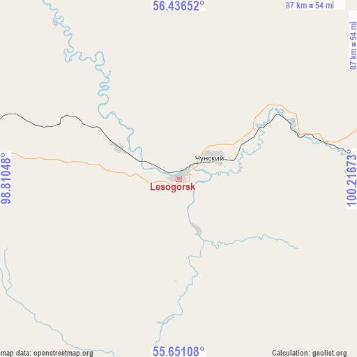
Lesogorsk GPS coordinates[2]
56° 2' 44.88" North, 99° 30' 48.96" East
| Map corner | latitude | longitude |
|---|---|---|
| Upper-left | 56.43652°, | 98.81048° |
| Center: | 56.0458°, | 99.5136° |
| Lower-right: | 55.65108°, | 100.21673° |
| Map W x H: | 87.3×87.3 km | = 54.2×54.2mi |
| max Lat: | 73.50819° ⇑32.8% North |
| Lesogorsk: | 56.0458° |
| min Lat: | ⇓67.2% South 41.28413° |
| min Long | Lesogorsk | max Long |
| -179.12198° | 99.5136° | 179.35046° |
| W 88%⇐ | ⇒12% E |
Elevation
Elevation of Lesogorsk is 265 m = 869 ft, and this is 62.4 m = 205 ft above average elevation for this country.
| Max E: |
2518 m = 8261 ft | 18.6% |
| Lesogorsk | 265 m 869 ft | |
| Avg. | 202.6 m = 665 ft | |
Min E: |
-28 m = -92 ft | 81.4% |
See also: Russia elevation on elevation.city.
Geographical zone
Lesogorsk is located in North temperate zone (between Tropic of Cancer and the Arctic Circle). Distance of this North polar circle is 1169.5 km =726.7 mi to North.| Distance of | km | miles | from Lesogorsk |
|---|---|---|---|
| North Pole | 3775.4 | 2345.9 | to North |
| Arctic Circle | 1169.5 | 726.7 | to North |
| Tropic Cancer | 3625.8 | 2253 | to South |
| Equator | 6231.7 | 3872.2 | to South |


Nearby cities:
15 places around Lesogorsk: (largest is in red/bold)
• Alzamay
76 km =47.2 mi,  224°
224°
• Atagay
105.1 km =65.3 mi,  184°
184°
• Biryusinsk
105.5 km =65.6 mi,  265°
265°
• Chunskiy
8.5 km =5.3 mi,  62°
62°
• Ilir
117.2 km =72.8 mi,  141°
141°
• Kvitok
64.2 km =39.9 mi, 272°
• Lesogorsk
4.5 km =2.8 mi,  275°
275°
• Nizhneudinsk
130.2 km =80.9 mi,  193°
193°
• Pokanayevka
125.7 km =78.1 mi,  294°
294°
• Pokosnoye
112.3 km =69.8 mi,  120°
120°
• Shitkino
80.3 km =49.9 mi,  296°
296°
• Tayshet
94.7 km =58.8 mi,  262°
262°
• Uk
115.1 km =71.5 mi,  200°
200°
• Vikhorevka
103.6 km =64.4 mi,  85°
85°
• Yurty
116.7 km =72.5 mi, 270°
Sources, notices
• [Note1] Compared only with cities in Russia existing in our database
• [Src1] Map data: © OpenStreetMap contributors (CC-BY-SA)
• [Src2] Other city data from geonames.org with taken over terms of usage.
• [Src3] Geographical zone / Annual Mean Temperature by Robert A. Rohde @ Wikipedia
