Uglekamensk geodata
Uglekamensk (Primorskiy (Maritime) Kray) is a populated place; located in Russia in Asia/Vladivostok (GMT+10) time zone. With population of 6,461 people, there are 2135 cities with bigger population in this country. Compared to other cities in Russia, 96.2% of cities are located further ↑North; 96.3% of cities are located further ←West and 61.4% of cities have higher elevation than Uglekamensk. Note1


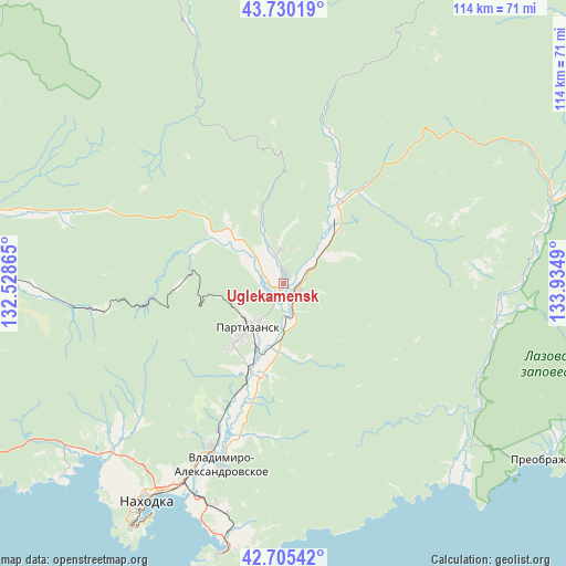
Uglekamensk GPS coordinates[2]
43° 13' 11.856" North, 133° 13' 54.372" East
| Map corner | latitude | longitude |
|---|---|---|
| Upper-left | 43.73019°, | 132.52865° |
| Center: | 43.21996°, | 133.23177° |
| Lower-right: | 42.70542°, | 133.9349° |
| Map W x H: | 113.9×113.9 km | = 70.8×70.8mi |
| max Lat: | 73.50819° ⇑96.2% North |
| Uglekamensk: | 43.21996° |
| min Lat: | ⇓3.8% South 41.28413° |
| min Long | Uglekamensk | max Long |
| -179.12198° | 133.23177° | 179.35046° |
| W 96.3%⇐ | ⇒3.7% E |
Elevation
Elevation of Uglekamensk is 121 m = 397 ft, and this is 81.6 m = 268 ft below average elevation for this country.
| Max E: |
2518 m = 8261 ft | 61.4% |
| Avg. | 202.6 m = 665 ft | |
| Uglekamensk | 121 m = 397 ft | |
Min E: |
-28 m = -92 ft | 38.6% |
See also: Russia elevation on elevation.city.
Geographical zone
Uglekamensk is located in North temperate zone (between Tropic of Cancer and the Arctic Circle). Distance of this Northern Tropic circle is 2199.7 km =1366.8 mi to South.| Distance of | km | miles | from Uglekamensk |
|---|---|---|---|
| North Pole | 5201.5 | 3232.1 | to North |
| Arctic Circle | 2595.6 | 1612.8 | to North |
| Tropic Cancer | 2199.7 | 1366.8 | to South |
| Equator | 4805.6 | 2986.1 | to South |


Nearby cities:
15 places around Uglekamensk: (largest is in red/bold)
• Bol’shoy Kamen’
72.2 km =44.9 mi,  260°
260°
• Lazo
57.6 km =35.8 mi,  71°
71°
• Livadiya
59.9 km =37.2 mi,  229°
229°
• Mnogoudobnoye
67.7 km =42.1 mi,  294°
294°
• Nakhodka
53.7 km =33.4 mi,  212°
212°
• Partizansk
14 km =8.7 mi,  218°
218°
• Preobrazheniye
65.1 km =40.5 mi,  122°
122°
• Romanovka
62.8 km =39 mi,  271°
271°
• Sergeyevka
17.7 km =11 mi,  35°
35°
• Shkotovo
71.9 km =44.7 mi,  278°
278°
• Smolyaninovo
63.3 km =39.3 mi, 276°
• Vladimiro-Aleksandrovskoye
38.6 km =24 mi,  198°
198°
• Volchanets
51.1 km =31.8 mi, 228°
• Vrangel’
55.8 km =34.7 mi,  192°
192°
• Yekaterinovka
36 km =22.4 mi, 204°
Sources, notices
• [Note1] Compared only with cities in Russia existing in our database
• [Src1] Map data: © OpenStreetMap contributors (CC-BY-SA)
• [Src2] Other city data from geonames.org with taken over terms of usage.
• [Src3] Geographical zone / Annual Mean Temperature by Robert A. Rohde @ Wikipedia
