Vladimiro-Aleksandrovskoye geodata
Vladimiro-Aleksandrovskoye (Primorskiy (Maritime) Kray) is a populated place; located in Russia in Asia/Vladivostok (GMT+10) time zone. With population of 5,444 people, there are 2457 cities with bigger population in this country. Compared to other cities in Russia, 97.9% of cities are located further ↑North; 96.2% of cities are located further ←West and 92.2% of cities have higher elevation than Vladimiro-Aleksandrovskoye. Note1
Current local time in Vladimiro-Aleksandrovskoye:
08:06 AM, FridayDifference from your time zone: hours


Vladimiro-Aleksandrovskoye GPS coordinates[2]
42° 53' 28.824" North, 133° 4' 40.836" East
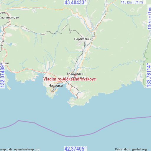
| Map corner | latitude | longitude |
|---|---|---|
| Upper-left | 43.40433°, | 132.37489° |
| Center: | 42.89134°, | 133.07801° |
| Lower-right: | 42.37405°, | 133.78114° |
| Map W x H: | 114.6×114.6 km | = 71.2×71.2mi |
| max Lat: | 73.50819° ⇑97.9% North |
| Vladimiro-Aleksandrovskoye: | 42.89134° |
| min Lat: | ⇓2.1% South 41.28413° |
| min Long | Vladimiro-Aleks | max Long |
| -179.12198° | 133.07801° | 179.35046° |
| W 96.2%⇐ | ⇒3.8% E |
Elevation
Elevation of Vladimiro-Aleksandrovskoye is 21 m = 69 ft, and this is 181.6 m = 596 ft below average elevation for this country.
| Max E: |
2518 m = 8261 ft | 92.2% |
| Avg. | 202.6 m = 665 ft | |
| Vladimiro-Aleksandrovskoye | 21 m = 69 ft | |
Min E: |
-28 m = -92 ft | 7.8% |
See also: Russia elevation on elevation.city.
Geographical zone
Vladimiro-Aleksandrovskoye is located in North temperate zone (between Tropic of Cancer and the Arctic Circle). Distance of this Northern Tropic circle is 2163.2 km =1344.1 mi to South.| Distance of | km | miles | from Vladimiro-Aleksandrovskoye |
|---|---|---|---|
| North Pole | 5238 | 3254.7 | to North |
| Arctic Circle | 2632.1 | 1635.5 | to North |
| Tropic Cancer | 2163.2 | 1344.1 | to South |
| Equator | 4769.1 | 2963.4 | to South |


Nearby cities:
15 places around Vladimiro-Aleksandrovskoye: (largest is in red/bold)
• Bol’shoy Kamen’
63.8 km =39.6 mi,  292°
292°
• Dunay
60.5 km =37.6 mi,  268°
268°
• Fokino
55.5 km =34.5 mi,  279°
279°
• Livadiya
33 km =20.5 mi, 265°
• Nakhodka
18.8 km =11.7 mi,  242°
242°
• Partizansk
25.9 km =16.1 mi,  8°
8°
• Preobrazheniye
67.3 km =41.8 mi,  89°
89°
• Putyatin
54.1 km =33.6 mi, 266°
• Romanovka
63.1 km =39.2 mi,  306°
306°
• Sergeyevka
55.8 km =34.7 mi,  24°
24°
• Smolyaninovo
67.1 km =41.7 mi, 311°
• Uglekamensk
38.6 km =24 mi, 18°
• Volchanets
25.8 km =16 mi, 275°
• Vrangel’
17.9 km =11.1 mi,  178°
178°
• Yekaterinovka
4.4 km =2.7 mi,  328°
328°
Sources, notices
• [Note1] Compared only with cities in Russia existing in our database
• [Src1] Map data: © OpenStreetMap contributors (CC-BY-SA)
• [Src2] Other city data from geonames.org with taken over terms of usage.
• [Src3] Geographical zone / Annual Mean Temperature by Robert A. Rohde @ Wikipedia
