Zdravnitsa geodata
Zdravnitsa (Moscow Oblast) is a populated place; located in Russia in Europe/Moscow (GMT+3) time zone. With population of 700 people, there are 4812 cities with bigger population in this country. Compared to other cities in Russia, 66% of cities are located further ↓South; 79.4% of cities are located further →East and 61.2% of cities have lower elevation than Zdravnitsa. Note1


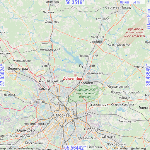
Zdravnitsa GPS coordinates[2]
55° 57' 36.036" North, 37° 44' 0.096" East
| Map corner | latitude | longitude |
|---|---|---|
| Upper-left | 56.3516°, | 37.03024° |
| Center: | 55.96001°, | 37.73336° |
| Lower-right: | 55.56442°, | 38.43649° |
| Map W x H: | 87.5×87.5 km | = 54.4×54.4mi |
| max Lat: | 73.50819° ⇑34% North |
| Zdravnitsa: | 55.96001° |
| min Lat: | ⇓66% South 41.28413° |
| min Long | Zdravnitsa | max Long |
| -179.12198° | 37.73336° | 179.35046° |
| W 20.6%⇐ | ⇒79.4% E |
Elevation
Elevation of Zdravnitsa is 172 m = 564 ft, and this is 30.6 m = 100 ft below average elevation for this country.
| Max E: |
2518 m = 8261 ft | 38.8% |
| Avg. | 202.6 m = 665 ft | |
| Zdravnitsa | 172 m = 564 ft | |
Min E: |
-28 m = -92 ft | 61.2% |
See also: Russia elevation on elevation.city.
Geographical zone
Zdravnitsa is located in North temperate zone (between Tropic of Cancer and the Arctic Circle). Distance of this North polar circle is 1179 km =732.6 mi to North.| Distance of | km | miles | from Zdravnitsa |
|---|---|---|---|
| North Pole | 3784.9 | 2351.8 | to North |
| Arctic Circle | 1179 | 732.6 | to North |
| Tropic Cancer | 3616.3 | 2247.1 | to South |
| Equator | 6222.2 | 3866.3 | to South |


Nearby cities:
15 places around Zdravnitsa: (largest is in red/bold)
• Belyaninovo
4.8 km =3 mi,  243°
243°
• Bolshevo
6.6 km =4.1 mi,  114°
114°
• Cherkizovo
3.8 km =2.4 mi,  62°
62°
• Druzhba
8.2 km =5.1 mi,  175°
175°
• Korolev
7.7 km =4.8 mi,  131°
131°
• Lesnyye Polyany
8.3 km =5.2 mi,  84°
84°
• Mamontovka
5.9 km =3.7 mi,  66°
66°
• Mytishchi
5.4 km =3.4 mi, 181°
• Pirogovo
2.6 km =1.6 mi,  359°
359°
• Pirogovskiy
2 km =1.2 mi,  0°
0°
• Poselok Turisticheskogo pansionata "Klyazminskoe vodohranilische"
5.5 km =3.4 mi,  315°
315°
• Povedniki
8.4 km =5.2 mi,  277°
277°
• Tarasovka
6.9 km =4.3 mi,  92°
92°
• Yubileyny
6.9 km =4.3 mi,  115°
115°
• Zhostovo
8.2 km =5.1 mi, 320°
Sources, notices
• [Note1] Compared only with cities in Russia existing in our database
• [Src1] Map data: © OpenStreetMap contributors (CC-BY-SA)
• [Src2] Other city data from geonames.org with taken over terms of usage.
• [Src3] Geographical zone / Annual Mean Temperature by Robert A. Rohde @ Wikipedia
