Bolshevo geodata
Bolshevo (Moscow Oblast) is a section of populated place; located in Russia in Europe/Moscow (GMT+3) time zone. With population of 10,133 people, there are 1490 cities with bigger population in this country. Compared to other cities in Russia, 65.6% of cities are located further ↓South; 78.6% of cities are located further →East and 56.3% of cities have lower elevation than Bolshevo. Note1


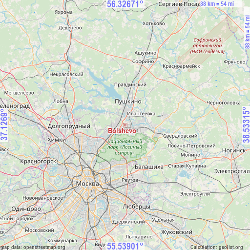
Bolshevo GPS coordinates[2]
55° 56' 5.496" North, 37° 49' 48.072" East
| Map corner | latitude | longitude |
|---|---|---|
| Upper-left | 56.32671°, | 37.1269° |
| Center: | 55.93486°, | 37.83002° |
| Lower-right: | 55.53901°, | 38.53315° |
| Map W x H: | 87.6×87.6 km | = 54.4×54.4mi |
| max Lat: | 73.50819° ⇑34.4% North |
| Bolshevo: | 55.93486° |
| min Lat: | ⇓65.6% South 41.28413° |
| min Long | Bolshevo | max Long |
| -179.12198° | 37.83002° | 179.35046° |
| W 21.4%⇐ | ⇒78.6% E |
Elevation
Elevation of Bolshevo is 159 m = 522 ft, and this is 43.6 m = 143 ft below average elevation for this country.
| Max E: |
2518 m = 8261 ft | 43.7% |
| Avg. | 202.6 m = 665 ft | |
| Bolshevo | 159 m = 522 ft | |
Min E: |
-28 m = -92 ft | 56.3% |
See also: Russia elevation on elevation.city.
Geographical zone
Bolshevo is located in North temperate zone (between Tropic of Cancer and the Arctic Circle). Distance of this North polar circle is 1181.8 km =734.3 mi to North.| Distance of | km | miles | from Bolshevo |
|---|---|---|---|
| North Pole | 3787.7 | 2353.6 | to North |
| Arctic Circle | 1181.8 | 734.3 | to North |
| Tropic Cancer | 3613.5 | 2245.3 | to South |
| Equator | 6219.4 | 3864.6 | to South |


Nearby cities:
15 places around Bolshevo: (largest is in red/bold)
• Cherkizovo
5.3 km =3.3 mi,  329°
329°
• Druzhba
7.7 km =4.8 mi,  225°
225°
• Ivanteyevka
6.9 km =4.3 mi,  54°
54°
• Korolev
2.3 km =1.4 mi,  186°
186°
• Lesnyye Polyany
4.2 km =2.6 mi,  32°
32°
• Mamontovka
5.2 km =3.2 mi,  352°
352°
• Mytishchi
6.7 km =4.2 mi,  247°
247°
• Pirogovo
8.1 km =5 mi,  311°
311°
• Pirogovskiy
7.7 km =4.8 mi, 308°
• Shchelkovo
8.9 km =5.5 mi,  97°
97°
• Tarasovka
2.6 km =1.6 mi,  18°
18°
• Yaroslavskiy
9.1 km =5.7 mi, 230°
• Yubileyny
0.3 km =0.2 mi,  129°
129°
• Zagoryanskiy
8 km =5 mi,  91°
91°
• Zdravnitsa
6.6 km =4.1 mi,  294°
294°
Sources, notices
• [Note1] Compared only with cities in Russia existing in our database
• [Src1] Map data: © OpenStreetMap contributors (CC-BY-SA)
• [Src2] Other city data from geonames.org with taken over terms of usage.
• [Src3] Geographical zone / Annual Mean Temperature by Robert A. Rohde @ Wikipedia
