Pirogovo geodata
Pirogovo (Moscow Oblast) is a populated place; located in Russia in Europe/Moscow (GMT+3) time zone. With population of 628 people, there are 4864 cities with bigger population in this country. Compared to other cities in Russia, 66.4% of cities are located further ↓South; 79.5% of cities are located further →East and 58.8% of cities have lower elevation than Pirogovo. Note1


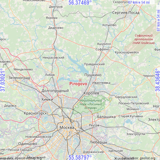
Pirogovo GPS coordinates[2]
55° 58' 59.988" North, 37° 43' 59.988" East
| Map corner | latitude | longitude |
|---|---|---|
| Upper-left | 56.37469°, | 37.03021° |
| Center: | 55.98333°, | 37.73333° |
| Lower-right: | 55.58797°, | 38.43646° |
| Map W x H: | 87.5×87.5 km | = 54.4×54.4mi |
| max Lat: | 73.50819° ⇑33.6% North |
| Pirogovo: | 55.98333° |
| min Lat: | ⇓66.4% South 41.28413° |
| min Long | Pirogovo | max Long |
| -179.12198° | 37.73333° | 179.35046° |
| W 20.5%⇐ | ⇒79.5% E |
Elevation
Elevation of Pirogovo is 165 m = 541 ft, and this is 37.6 m = 123 ft below average elevation for this country.
| Max E: |
2518 m = 8261 ft | 41.2% |
| Avg. | 202.6 m = 665 ft | |
| Pirogovo | 165 m = 541 ft | |
Min E: |
-28 m = -92 ft | 58.8% |
See also: Russia elevation on elevation.city.
Geographical zone
Pirogovo is located in North temperate zone (between Tropic of Cancer and the Arctic Circle). Distance of this North polar circle is 1176.4 km =731 mi to North.| Distance of | km | miles | from Pirogovo |
|---|---|---|---|
| North Pole | 3782.3 | 2350.2 | to North |
| Arctic Circle | 1176.4 | 731 | to North |
| Tropic Cancer | 3618.8 | 2248.6 | to South |
| Equator | 6224.8 | 3867.9 | to South |


Nearby cities:
15 places around Pirogovo: (largest is in red/bold)
• Belyaninovo
6.4 km =4 mi,  222°
222°
• Bolshevo
8.1 km =5 mi,  131°
131°
• Cherkizovo
3.5 km =2.2 mi,  103°
103°
• Korolev
9.6 km =6 mi,  143°
143°
• Lesnyye Polyany
8.5 km =5.3 mi, 102°
• Mamontovka
5.4 km =3.4 mi,  92°
92°
• Mytishchi
8 km =5 mi,  181°
181°
• Pirogovskiy
0.6 km =0.4 mi, 178°
• Poselok Turisticheskogo pansionata "Klyazminskoe vodohranilische"
4 km =2.5 mi,  288°
288°
• Povedniki
8.4 km =5.2 mi,  259°
259°
• Pushkino
9.1 km =5.7 mi,  65°
65°
• Tarasovka
7.4 km =4.6 mi,  112°
112°
• Yubileyny
8.3 km =5.2 mi, 131°
• Zdravnitsa
2.6 km =1.6 mi, 179°
• Zhostovo
6.4 km =4 mi,  305°
305°
Sources, notices
• [Note1] Compared only with cities in Russia existing in our database
• [Src1] Map data: © OpenStreetMap contributors (CC-BY-SA)
• [Src2] Other city data from geonames.org with taken over terms of usage.
• [Src3] Geographical zone / Annual Mean Temperature by Robert A. Rohde @ Wikipedia
