Mamontovka geodata
Mamontovka (Moscow Oblast) is a populated place; located in Russia in Europe/Moscow (GMT+3) time zone. With population of 8,817 people, there are 1682 cities with bigger population in this country. Compared to other cities in Russia, 66.4% of cities are located further ↓South; 78.7% of cities are located further →East and 56.8% of cities have lower elevation than Mamontovka. Note1


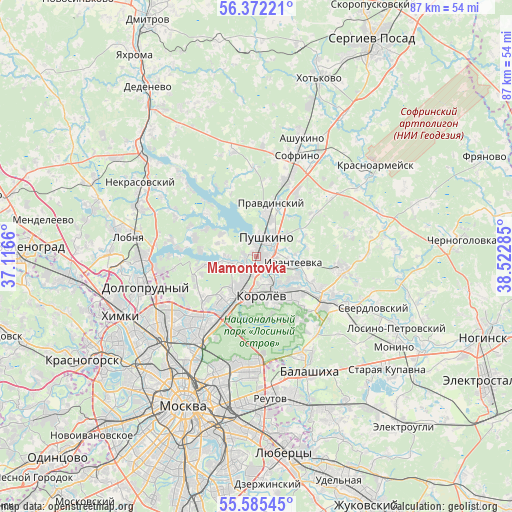
Mamontovka GPS coordinates[2]
55° 58' 50.988" North, 37° 49' 10.992" East
| Map corner | latitude | longitude |
|---|---|---|
| Upper-left | 56.37221°, | 37.1166° |
| Center: | 55.98083°, | 37.81972° |
| Lower-right: | 55.58545°, | 38.52285° |
| Map W x H: | 87.5×87.5 km | = 54.4×54.4mi |
| max Lat: | 73.50819° ⇑33.6% North |
| Mamontovka: | 55.98083° |
| min Lat: | ⇓66.4% South 41.28413° |
| min Long | Mamontovka | max Long |
| -179.12198° | 37.81972° | 179.35046° |
| W 21.3%⇐ | ⇒78.7% E |
Elevation
Elevation of Mamontovka is 160 m = 525 ft, and this is 42.6 m = 140 ft below average elevation for this country.
| Max E: |
2518 m = 8261 ft | 43.2% |
| Avg. | 202.6 m = 665 ft | |
| Mamontovka | 160 m = 525 ft | |
Min E: |
-28 m = -92 ft | 56.8% |
See also: Russia elevation on elevation.city.
Geographical zone
Mamontovka is located in North temperate zone (between Tropic of Cancer and the Arctic Circle). Distance of this North polar circle is 1176.7 km =731.2 mi to North.| Distance of | km | miles | from Mamontovka |
|---|---|---|---|
| North Pole | 3782.6 | 2350.4 | to North |
| Arctic Circle | 1176.7 | 731.2 | to North |
| Tropic Cancer | 3618.6 | 2248.5 | to South |
| Equator | 6224.5 | 3867.7 | to South |


Nearby cities:
15 places around Mamontovka: (largest is in red/bold)
• Bolshevo
5.2 km =3.2 mi,  172°
172°
• Bratovshchina
8.6 km =5.3 mi,  27°
27°
• Cherkizovo
2.1 km =1.3 mi,  254°
254°
• Ivanteyevka
6.4 km =4 mi,  99°
99°
• Korolev
7.4 km =4.6 mi,  177°
177°
• Kostino
8.4 km =5.2 mi,  45°
45°
• Lesnyye Polyany
3.3 km =2.1 mi,  118°
118°
• Pirogovo
5.4 km =3.4 mi,  272°
272°
• Pirogovskiy
5.4 km =3.4 mi, 266°
• Poselok Turisticheskogo pansionata "Klyazminskoe vodohranilische"
9.3 km =5.8 mi,  279°
279°
• Pravdinskiy
9.2 km =5.7 mi,  16°
16°
• Pushkino
5 km =3.1 mi,  35°
35°
• Tarasovka
3 km =1.9 mi,  150°
150°
• Yubileyny
5.3 km =3.3 mi, 170°
• Zdravnitsa
5.9 km =3.7 mi, 246°
Sources, notices
• [Note1] Compared only with cities in Russia existing in our database
• [Src1] Map data: © OpenStreetMap contributors (CC-BY-SA)
• [Src2] Other city data from geonames.org with taken over terms of usage.
• [Src3] Geographical zone / Annual Mean Temperature by Robert A. Rohde @ Wikipedia
