Peresvet geodata
Peresvet (Moscow Oblast) is a populated place; located in Russia in Europe/Moscow (GMT+3) time zone. With population of 15,000 people, there are 1092 cities with bigger population in this country. Compared to other cities in Russia, 71.8% of cities are located further ↓South; 76% of cities are located further →East and 75.7% of cities have lower elevation than Peresvet. Note1


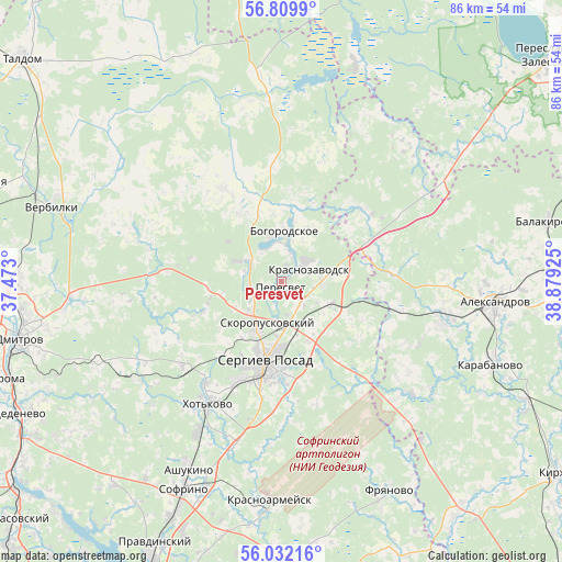
Peresvet GPS coordinates[2]
56° 25' 22.872" North, 38° 10' 34.032" East
| Map corner | latitude | longitude |
|---|---|---|
| Upper-left | 56.8099°, | 37.473° |
| Center: | 56.42302°, | 38.17612° |
| Lower-right: | 56.03216°, | 38.87925° |
| Map W x H: | 86.5×86.5 km | = 53.7×53.7mi |
| max Lat: | 73.50819° ⇑28.2% North |
| Peresvet: | 56.42302° |
| min Lat: | ⇓71.8% South 41.28413° |
| min Long | Peresvet | max Long |
| -179.12198° | 38.17612° | 179.35046° |
| W 24%⇐ | ⇒76% E |
Elevation
Elevation of Peresvet is 220 m = 722 ft, and this is 17.4 m = 57 ft above average elevation for this country.
| Max E: |
2518 m = 8261 ft | 24.3% |
| Peresvet | 220 m 722 ft | |
| Avg. | 202.6 m = 665 ft | |
Min E: |
-28 m = -92 ft | 75.7% |
See also: Russia elevation on elevation.city.
Geographical zone
Peresvet is located in North temperate zone (between Tropic of Cancer and the Arctic Circle). Distance of this North polar circle is 1127.5 km =700.6 mi to North.| Distance of | km | miles | from Peresvet |
|---|---|---|---|
| North Pole | 3733.4 | 2319.8 | to North |
| Arctic Circle | 1127.5 | 700.6 | to North |
| Tropic Cancer | 3667.7 | 2279 | to South |
| Equator | 6273.7 | 3898.3 | to South |


Nearby cities:
15 places around Peresvet: (largest is in red/bold)
• Arsaki
19.4 km =12.1 mi,  103°
103°
• Bogorodskoye
8.6 km =5.3 mi,  2°
2°
• Bogorodskoye
22.9 km =14.2 mi,  308°
308°
• Khot'kovo
21.6 km =13.4 mi,  211°
211°
• Konstantinovo
16.6 km =10.3 mi,  328°
328°
• Krasnozavodsk
3.9 km =2.4 mi,  39°
39°
• Mukhanovo
12.2 km =7.6 mi,  45°
45°
• Semenkovo
5.1 km =3.2 mi,  87°
87°
• Semkhoz
16.9 km =10.5 mi,  203°
203°
• Sergiyev Posad
13.9 km =8.6 mi,  190°
190°
• Shaburnovo
20.5 km =12.7 mi, 313°
• Shemëtovo
13.2 km =8.2 mi, 331°
• Skoropuskovskiy
6.3 km =3.9 mi, 185°
• Strunino
25.7 km =16 mi, 102°
• Svatkovo
5.1 km =3.2 mi,  150°
150°
Sources, notices
• [Note1] Compared only with cities in Russia existing in our database
• [Src1] Map data: © OpenStreetMap contributors (CC-BY-SA)
• [Src2] Other city data from geonames.org with taken over terms of usage.
• [Src3] Geographical zone / Annual Mean Temperature by Robert A. Rohde @ Wikipedia
