Arsaki geodata
Arsaki (Vladimir) is a populated place; located in Russia in Europe/Moscow (GMT+3) time zone. With population of 3,059 people, there are 3735 cities with bigger population in this country. Compared to other cities in Russia, 71.5% of cities are located further ↓South; 74.5% of cities are located further →East and 68% of cities have lower elevation than Arsaki. Note1


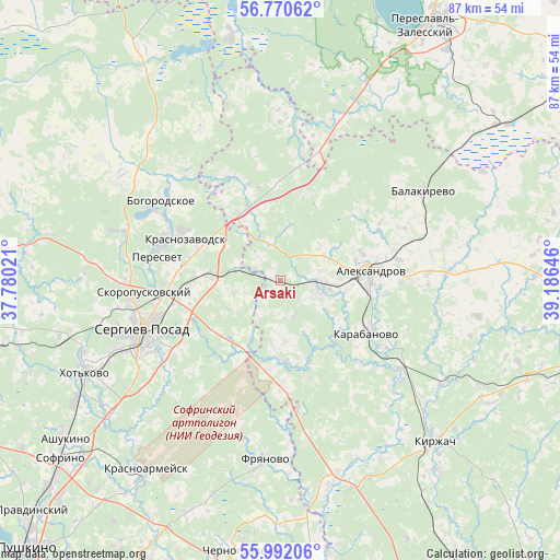
Arsaki GPS coordinates[2]
56° 22' 59.988" North, 38° 28' 59.988" East
| Map corner | latitude | longitude |
|---|---|---|
| Upper-left | 56.77062°, | 37.78021° |
| Center: | 56.38333°, | 38.48333° |
| Lower-right: | 55.99206°, | 39.18646° |
| Map W x H: | 86.6×86.6 km | = 53.8×53.8mi |
| max Lat: | 73.50819° ⇑28.5% North |
| Arsaki: | 56.38333° |
| min Lat: | ⇓71.5% South 41.28413° |
| min Long | Arsaki | max Long |
| -179.12198° | 38.48333° | 179.35046° |
| W 25.5%⇐ | ⇒74.5% E |
Elevation
Elevation of Arsaki is 191 m = 627 ft, and this is 11.6 m = 38 ft below average elevation for this country.
| Max E: |
2518 m = 8261 ft | 32% |
| Avg. | 202.6 m = 665 ft | |
| Arsaki | 191 m = 627 ft | |
Min E: |
-28 m = -92 ft | 68% |
See also: Russia elevation on elevation.city.
Geographical zone
Arsaki is located in North temperate zone (between Tropic of Cancer and the Arctic Circle). Distance of this North polar circle is 1131.9 km =703.3 mi to North.| Distance of | km | miles | from Arsaki |
|---|---|---|---|
| North Pole | 3737.8 | 2322.6 | to North |
| Arctic Circle | 1131.9 | 703.3 | to North |
| Tropic Cancer | 3663.3 | 2276.3 | to South |
| Equator | 6269.2 | 3895.5 | to South |


Nearby cities:
15 places around Arsaki: (largest is in red/bold)
• Aleksandrov
14.1 km =8.8 mi,  84°
84°
• Balakirevo
26 km =16.2 mi,  58°
58°
• Bogorodskoye
22.5 km =14 mi,  305°
305°
• Fryanovo
27.9 km =17.3 mi,  184°
184°
• Karabanovo
15.3 km =9.5 mi,  119°
119°
• Krasnozavodsk
18 km =11.2 mi,  294°
294°
• Mukhanovo
16.5 km =10.3 mi,  321°
321°
• Novoye
25.8 km =16 mi,  20°
20°
• Peresvet
19.4 km =12.1 mi,  283°
283°
• Semenkovo
14.6 km =9.1 mi, 288°
• Semkhoz
28 km =17.4 mi,  246°
246°
• Sergiyev Posad
23.5 km =14.6 mi, 246°
• Skoropuskovskiy
19.6 km =12.2 mi,  264°
264°
• Strunino
6.2 km =3.9 mi,  100°
100°
• Svatkovo
16.4 km =10.2 mi,  270°
270°
Sources, notices
• [Note1] Compared only with cities in Russia existing in our database
• [Src1] Map data: © OpenStreetMap contributors (CC-BY-SA)
• [Src2] Other city data from geonames.org with taken over terms of usage.
• [Src3] Geographical zone / Annual Mean Temperature by Robert A. Rohde @ Wikipedia
