Svatkovo geodata
Svatkovo (Moscow Oblast) is a populated place; located in Russia in Europe/Moscow (GMT+3) time zone. With population of 1,850 people, there are 4235 cities with bigger population in this country. Compared to other cities in Russia, 71.5% of cities are located further ↓South; 75.7% of cities are located further →East and 73.2% of cities have lower elevation than Svatkovo. Note1


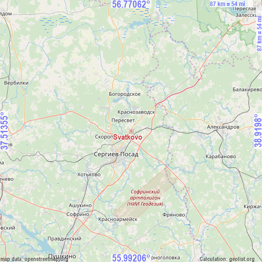
Svatkovo GPS coordinates[2]
56° 22' 59.988" North, 38° 13' 0.012" East
| Map corner | latitude | longitude |
|---|---|---|
| Upper-left | 56.77062°, | 37.51355° |
| Center: | 56.38333°, | 38.21667° |
| Lower-right: | 55.99206°, | 38.9198° |
| Map W x H: | 86.6×86.6 km | = 53.8×53.8mi |
| max Lat: | 73.50819° ⇑28.5% North |
| Svatkovo: | 56.38333° |
| min Lat: | ⇓71.5% South 41.28413° |
| min Long | Svatkovo | max Long |
| -179.12198° | 38.21667° | 179.35046° |
| W 24.3%⇐ | ⇒75.7% E |
Elevation
Elevation of Svatkovo is 209 m = 686 ft, and this is 6.4 m = 21 ft above average elevation for this country.
| Max E: |
2518 m = 8261 ft | 26.8% |
| Svatkovo | 209 m 686 ft | |
| Avg. | 202.6 m = 665 ft | |
Min E: |
-28 m = -92 ft | 73.2% |
See also: Russia elevation on elevation.city.
Geographical zone
Svatkovo is located in North temperate zone (between Tropic of Cancer and the Arctic Circle). Distance of this North polar circle is 1131.9 km =703.3 mi to North.| Distance of | km | miles | from Svatkovo |
|---|---|---|---|
| North Pole | 3737.8 | 2322.6 | to North |
| Arctic Circle | 1131.9 | 703.3 | to North |
| Tropic Cancer | 3663.3 | 2276.3 | to South |
| Equator | 6269.2 | 3895.5 | to South |


Nearby cities:
15 places around Svatkovo: (largest is in red/bold)
• Arsaki
16.4 km =10.2 mi,  90°
90°
• Bogorodskoye
13.1 km =8.1 mi,  351°
351°
• Bogorodskoye
27.6 km =17.1 mi,  312°
312°
• Khot'kovo
19.6 km =12.2 mi,  224°
224°
• Konstantinovo
21.7 km =13.5 mi,  328°
328°
• Krasnozavodsk
7.4 km =4.6 mi,  0°
0°
• Mukhanovo
14.4 km =8.9 mi,  25°
25°
• Peresvet
5.1 km =3.2 mi, 330°
• Semenkovo
5.3 km =3.3 mi, 29°
• Semkhoz
14.5 km =9 mi, 219°
• Sergiyev Posad
10.6 km =6.6 mi,  208°
208°
• Shaburnovo
25.4 km =15.8 mi,  316°
316°
• Shemëtovo
18.2 km =11.3 mi, 331°
• Skoropuskovskiy
3.6 km =2.2 mi,  238°
238°
• Strunino
22.6 km =14 mi, 92°
Sources, notices
• [Note1] Compared only with cities in Russia existing in our database
• [Src1] Map data: © OpenStreetMap contributors (CC-BY-SA)
• [Src2] Other city data from geonames.org with taken over terms of usage.
• [Src3] Geographical zone / Annual Mean Temperature by Robert A. Rohde @ Wikipedia
