Strunino geodata
Strunino (Vladimir) is a populated place; located in Russia in Europe/Moscow (GMT+3) time zone. With population of 15,483 people, there are 1062 cities with bigger population in this country. Compared to other cities in Russia, 71.4% of cities are located further ↓South; 74.1% of cities are located further →East and 60.3% of cities have lower elevation than Strunino. Note1


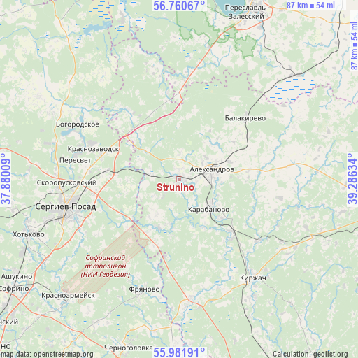
Strunino GPS coordinates[2]
56° 22' 23.808" North, 38° 34' 59.556" East
| Map corner | latitude | longitude |
|---|---|---|
| Upper-left | 56.76067°, | 37.88009° |
| Center: | 56.37328°, | 38.58321° |
| Lower-right: | 55.98191°, | 39.28634° |
| Map W x H: | 86.6×86.6 km | = 53.8×53.8mi |
| max Lat: | 73.50819° ⇑28.6% North |
| Strunino: | 56.37328° |
| min Lat: | ⇓71.4% South 41.28413° |
| min Long | Strunino | max Long |
| -179.12198° | 38.58321° | 179.35046° |
| W 25.9%⇐ | ⇒74.1% E |
Elevation
Elevation of Strunino is 169 m = 554 ft, and this is 33.6 m = 110 ft below average elevation for this country.
| Max E: |
2518 m = 8261 ft | 39.7% |
| Avg. | 202.6 m = 665 ft | |
| Strunino | 169 m = 554 ft | |
Min E: |
-28 m = -92 ft | 60.3% |
See also: Russia elevation on elevation.city.
Geographical zone
Strunino is located in North temperate zone (between Tropic of Cancer and the Arctic Circle). Distance of this North polar circle is 1133.1 km =704.1 mi to North.| Distance of | km | miles | from Strunino |
|---|---|---|---|
| North Pole | 3738.9 | 2323.2 | to North |
| Arctic Circle | 1133.1 | 704.1 | to North |
| Tropic Cancer | 3662.2 | 2275.6 | to South |
| Equator | 6268.1 | 3894.8 | to South |


Nearby cities:
15 places around Strunino: (largest is in red/bold)
• Aleksandrov
8.3 km =5.2 mi,  72°
72°
• Arsaki
6.2 km =3.9 mi,  280°
280°
• Balakirevo
21.7 km =13.5 mi,  47°
47°
• Bogorodskoye
28.3 km =17.6 mi,  299°
299°
• Fryanovo
27.9 km =17.3 mi,  197°
197°
• Karabanovo
9.6 km =6 mi,  131°
131°
• Kirzhach
29.7 km =18.5 mi,  145°
145°
• Krasnozavodsk
24.1 km =15 mi,  290°
290°
• Mukhanovo
21.6 km =13.4 mi,  310°
310°
• Novoye
25.4 km =15.8 mi,  6°
6°
• Peresvet
25.7 km =16 mi, 282°
• Semenkovo
20.8 km =12.9 mi, 285°
• Sergiyev Posad
28.9 km =18 mi,  253°
253°
• Skoropuskovskiy
25.7 km =16 mi,  268°
268°
• Svatkovo
22.6 km =14 mi, 272°
Sources, notices
• [Note1] Compared only with cities in Russia existing in our database
• [Src1] Map data: © OpenStreetMap contributors (CC-BY-SA)
• [Src2] Other city data from geonames.org with taken over terms of usage.
• [Src3] Geographical zone / Annual Mean Temperature by Robert A. Rohde @ Wikipedia
