Zhigulevsk geodata
Zhigulevsk (Samara Oblast) is a populated place; located in Russia in Europe/Samara (GMT+4) time zone. With population of 57,094 people, there are 367 cities with bigger population in this country. Compared to other cities in Russia, 59.5% of cities are located further ↑North; 61.3% of cities are located further ←West and 78.7% of cities have higher elevation than Zhigulevsk. Note1


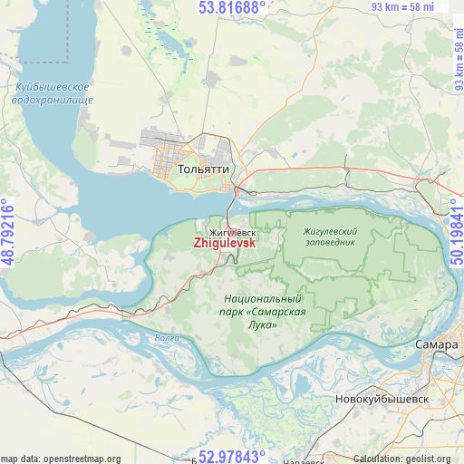
Zhigulevsk GPS coordinates[2]
53° 23' 58.992" North, 49° 29' 43.008" East
| Map corner | latitude | longitude |
|---|---|---|
| Upper-left | 53.81688°, | 48.79216° |
| Center: | 53.39972°, | 49.49528° |
| Lower-right: | 52.97843°, | 50.19841° |
| Map W x H: | 93.2×93.2 km | = 57.9×57.9mi |
| max Lat: | 73.50819° ⇑59.5% North |
| Zhigulevsk: | 53.39972° |
| min Lat: | ⇓40.5% South 41.28413° |
| min Long | Zhigulevsk | max Long |
| -179.12198° | 49.49528° | 179.35046° |
| W 61.3%⇐ | ⇒38.7% E |
Elevation
Elevation of Zhigulevsk is 75 m = 246 ft, and this is 127.6 m = 419 ft below average elevation for this country.
| Max E: |
2518 m = 8261 ft | 78.7% |
| Avg. | 202.6 m = 665 ft | |
| Zhigulevsk | 75 m = 246 ft | |
Min E: |
-28 m = -92 ft | 21.3% |
See also: Zhigulevsk elevation on elevation.city.
Geographical zone
Zhigulevsk is located in North temperate zone (between Tropic of Cancer and the Arctic Circle). Distance of this North polar circle is 1463.7 km =909.5 mi to North.| Distance of | km | miles | from Zhigulevsk |
|---|---|---|---|
| North Pole | 4069.6 | 2528.7 | to North |
| Arctic Circle | 1463.7 | 909.5 | to North |
| Tropic Cancer | 3331.6 | 2070.2 | to South |
| Equator | 5937.5 | 3689.4 | to South |


Nearby cities:
15 places around Zhigulevsk: (largest is in red/bold)
• Bakhilovo
9.3 km =5.8 mi,  89°
89°
• Bogatyr’
30 km =18.6 mi,  83°
83°
• Bol’shaya Ryazan’
20.3 km =12.6 mi,  219°
219°
• Kurumoch
37.3 km =23.2 mi,  74°
74°
• Mezhdurechensk
29.5 km =18.3 mi,  239°
239°
• Perevoloki
27.1 km =16.8 mi,  230°
230°
• Podstepki
27.1 km =16.8 mi,  298°
298°
• Povolzhskiy
27.2 km =16.9 mi,  40°
40°
• Pribrezhnyy
25.9 km =16.1 mi, 68°
• Rozhdestveno
41.6 km =25.8 mi,  115°
115°
• Tol’yatti
17.6 km =10.9 mi,  325°
325°
• Valy
10.2 km =6.3 mi, 215°
• Volzhskiy
41.5 km =25.8 mi, 85°
• Zhiguli
13.7 km =8.5 mi,  250°
250°
• Zol’noye
20.6 km =12.8 mi, 76°
Sources, notices
• [Note1] Compared only with cities in Russia existing in our database
• [Src1] Map data: © OpenStreetMap contributors (CC-BY-SA)
• [Src2] Other city data from geonames.org with taken over terms of usage.
• [Src3] Geographical zone / Annual Mean Temperature by Robert A. Rohde @ Wikipedia
