Tol’yatti geodata
Tol’yatti (Samara Oblast) is a populated place; located in Russia in Europe/Samara (GMT+4) time zone. With population of 702,879 people, there are 16 cities with bigger population in this country. Compared to other cities in Russia, 58.6% of cities are located further ↑North; 61.2% of cities are located further ←West and 73.8% of cities have higher elevation than Tol’yatti. Note1


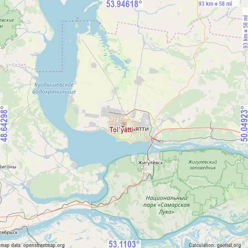
Tol’yatti GPS coordinates[2]
53° 31' 49.08" North, 49° 20' 45.96" East
| Map corner | latitude | longitude |
|---|---|---|
| Upper-left | 53.94618°, | 48.64298° |
| Center: | 53.5303°, | 49.3461° |
| Lower-right: | 53.1103°, | 50.04923° |
| Map W x H: | 92.9×92.9 km | = 57.7×57.7mi |
| max Lat: | 73.50819° ⇑58.6% North |
| Tol’yatti: | 53.5303° |
| min Lat: | ⇓41.4% South 41.28413° |
| min Long | Tol’yatti | max Long |
| -179.12198° | 49.3461° | 179.35046° |
| W 61.2%⇐ | ⇒38.8% E |
Elevation
Elevation of Tol’yatti is 92 m = 302 ft, and this is 110.6 m = 363 ft below average elevation for this country.
| Max E: |
2518 m = 8261 ft | 73.8% |
| Avg. | 202.6 m = 665 ft | |
| Tol’yatti | 92 m = 302 ft | |
Min E: |
-28 m = -92 ft | 26.2% |
See also: Tol’yatti elevation on elevation.city.
Geographical zone
Tol’yatti is located in North temperate zone (between Tropic of Cancer and the Arctic Circle). Distance of this North polar circle is 1449.2 km =900.5 mi to North.| Distance of | km | miles | from Tol’yatti |
|---|---|---|---|
| North Pole | 4055.1 | 2519.7 | to North |
| Arctic Circle | 1449.2 | 900.5 | to North |
| Tropic Cancer | 3346.1 | 2079.2 | to South |
| Equator | 5952 | 3698.4 | to South |


Nearby cities:
15 places around Tol’yatti: (largest is in red/bold)
• Bakhilovo
24 km =14.9 mi,  126°
126°
• Bogatyr’
41.2 km =25.6 mi,  105°
105°
• Bol’shaya Ryazan’
30.4 km =18.9 mi,  185°
185°
• Khryashchevka
35.5 km =22.1 mi,  331°
331°
• Kurumoch
45.9 km =28.5 mi,  95°
95°
• Mezhdurechensk
33.2 km =20.6 mi,  207°
207°
• Perevoloki
33.5 km =20.8 mi,  199°
199°
• Podstepki
14 km =8.7 mi,  263°
263°
• Povolzhskiy
28.2 km =17.5 mi,  77°
77°
• Pribrezhnyy
34.2 km =21.3 mi, 98°
• Shigony
47 km =29.2 mi,  250°
250°
• Valy
23.1 km =14.4 mi,  170°
170°
• Zhigulevsk
17.6 km =10.9 mi,  145°
145°
• Zhiguli
19.4 km =12.1 mi, 188°
• Zol’noye
31.5 km =19.6 mi, 108°
In other languages:
- In Spanish: Toliatti
- In France: Togliatti
- In German: Toljatti
- In Italian: Togliattigrad
- In Russian: Тольятти
- In Chinese: 陶里亚蒂
Sources, notices
• [Note1] Compared only with cities in Russia existing in our database
• [Src1] Map data: © OpenStreetMap contributors (CC-BY-SA)
• [Src2] Other city data from geonames.org with taken over terms of usage.
• [Src3] Geographical zone / Annual Mean Temperature by Robert A. Rohde @ Wikipedia
