Rybkhoz geodata
Rybkhoz (Moscow Oblast) is a populated place; located in Russia in Europe/Moscow (GMT+3) time zone. With population of 853 people, there are 4729 cities with bigger population in this country. Compared to other cities in Russia, 63.4% of cities are located further ↓South; 76.2% of cities are located further →East and 53.1% of cities have higher elevation than Rybkhoz. Note1


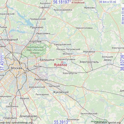
Rybkhoz GPS coordinates[2]
55° 47' 19.104" North, 38° 8' 3.228" East
| Map corner | latitude | longitude |
|---|---|---|
| Upper-left | 56.18197°, | 37.43111° |
| Center: | 55.78864°, | 38.13423° |
| Lower-right: | 55.3913°, | 38.83736° |
| Map W x H: | 87.9×87.9 km | = 54.6×54.6mi |
| max Lat: | 73.50819° ⇑36.6% North |
| Rybkhoz: | 55.78864° |
| min Lat: | ⇓63.4% South 41.28413° |
| min Long | Rybkhoz | max Long |
| -179.12198° | 38.13423° | 179.35046° |
| W 23.8%⇐ | ⇒76.2% E |
Elevation
Elevation of Rybkhoz is 138 m = 453 ft, and this is 64.6 m = 212 ft below average elevation for this country.
| Max E: |
2518 m = 8261 ft | 53.1% |
| Avg. | 202.6 m = 665 ft | |
| Rybkhoz | 138 m = 453 ft | |
Min E: |
-28 m = -92 ft | 46.9% |
See also: Russia elevation on elevation.city.
Geographical zone
Rybkhoz is located in North temperate zone (between Tropic of Cancer and the Arctic Circle). Distance of this North polar circle is 1198.1 km =744.5 mi to North.| Distance of | km | miles | from Rybkhoz |
|---|---|---|---|
| North Pole | 3803.9 | 2363.6 | to North |
| Arctic Circle | 1198.1 | 744.5 | to North |
| Tropic Cancer | 3597.2 | 2235.2 | to South |
| Equator | 6203.1 | 3854.4 | to South |


Nearby cities:
15 places around Rybkhoz: (largest is in red/bold)
• Bakhchivandzhi
11 km =6.8 mi,  343°
343°
• Chornoye
6.3 km =3.9 mi,  220°
220°
• Elektrougli
8.5 km =5.3 mi,  146°
146°
• Fedurnovo
6.6 km =4.1 mi,  235°
235°
• Kupavna
4.8 km =3 mi,  182°
182°
• Losino-Petrovskiy
9.9 km =6.2 mi,  24°
24°
• Monino
7 km =4.3 mi,  31°
31°
• Novaya Kupavna
3.3 km =2.1 mi,  331°
331°
• Novyy Milet
10.2 km =6.3 mi,  207°
207°
• Obukhovo
9.9 km =6.2 mi,  60°
60°
• Purshevo
9.8 km =6.1 mi, 220°
• Staraya Kupavna
3.6 km =2.2 mi,  53°
53°
• Vishnyakovskiye Dachi
2.7 km =1.7 mi, 181°
• Zarya
4.4 km =2.7 mi, 212°
• Zheleznodorozhnyy
8.9 km =5.5 mi, 235°
Sources, notices
• [Note1] Compared only with cities in Russia existing in our database
• [Src1] Map data: © OpenStreetMap contributors (CC-BY-SA)
• [Src2] Other city data from geonames.org with taken over terms of usage.
• [Src3] Geographical zone / Annual Mean Temperature by Robert A. Rohde @ Wikipedia
