Obukhovo geodata
Obukhovo (Moscow Oblast) is a populated place; located in Russia in Europe/Moscow (GMT+3) time zone. With population of 10,616 people, there are 1427 cities with bigger population in this country. Compared to other cities in Russia, 64.1% of cities are located further ↓South; 75.4% of cities are located further →East and 55.1% of cities have higher elevation than Obukhovo. Note1


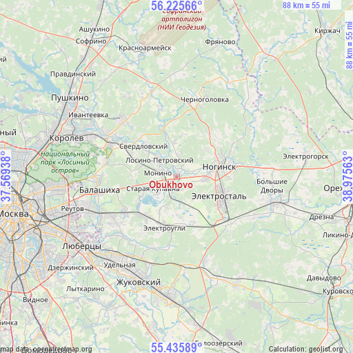
Obukhovo GPS coordinates[2]
55° 49' 58.008" North, 38° 16' 21" East
| Map corner | latitude | longitude |
|---|---|---|
| Upper-left | 56.22566°, | 37.56938° |
| Center: | 55.83278°, | 38.2725° |
| Lower-right: | 55.43589°, | 38.97563° |
| Map W x H: | 87.8×87.8 km | = 54.6×54.6mi |
| max Lat: | 73.50819° ⇑35.9% North |
| Obukhovo: | 55.83278° |
| min Lat: | ⇓64.1% South 41.28413° |
| min Long | Obukhovo | max Long |
| -179.12198° | 38.2725° | 179.35046° |
| W 24.6%⇐ | ⇒75.4% E |
Elevation
Elevation of Obukhovo is 134 m = 440 ft, and this is 68.6 m = 225 ft below average elevation for this country.
| Max E: |
2518 m = 8261 ft | 55.1% |
| Avg. | 202.6 m = 665 ft | |
| Obukhovo | 134 m = 440 ft | |
Min E: |
-28 m = -92 ft | 44.9% |
See also: Russia elevation on elevation.city.
Geographical zone
Obukhovo is located in North temperate zone (between Tropic of Cancer and the Arctic Circle). Distance of this North polar circle is 1193.2 km =741.4 mi to North.| Distance of | km | miles | from Obukhovo |
|---|---|---|---|
| North Pole | 3799 | 2360.6 | to North |
| Arctic Circle | 1193.2 | 741.4 | to North |
| Tropic Cancer | 3602.1 | 2238.2 | to South |
| Equator | 6208 | 3857.5 | to South |


Nearby cities:
15 places around Obukhovo: (largest is in red/bold)
• Bakhchivandzhi
13.1 km =8.1 mi,  295°
295°
• Elektrostal’
11.9 km =7.4 mi,  113°
113°
• Elektrougli
12.7 km =7.9 mi,  198°
198°
• Imeni Vorovskogo
11.7 km =7.3 mi,  164°
164°
• Kupavna
13.1 km =8.1 mi,  222°
222°
• Losino-Petrovskiy
6.1 km =3.8 mi,  312°
312°
• Monino
5 km =3.1 mi,  282°
282°
• Noginsk
11.3 km =7 mi,  70°
70°
• Novaya Kupavna
10.4 km =6.5 mi,  258°
258°
• Rybkhoz
9.9 km =6.2 mi,  240°
240°
• Staraya Kupavna
6.4 km =4 mi, 244°
• Sverdlovskiy
11.5 km =7.1 mi,  318°
318°
• Vishnyakovskiye Dachi
11.5 km =7.1 mi,  228°
228°
• Yamkino
12.8 km =8 mi,  39°
39°
• Zarya
14 km =8.7 mi, 232°
Sources, notices
• [Note1] Compared only with cities in Russia existing in our database
• [Src1] Map data: © OpenStreetMap contributors (CC-BY-SA)
• [Src2] Other city data from geonames.org with taken over terms of usage.
• [Src3] Geographical zone / Annual Mean Temperature by Robert A. Rohde @ Wikipedia
