Zubtsov geodata
Zubtsov (Tver’ Oblast) is a populated place; located in Russia in Europe/Moscow (GMT+3) time zone. With population of 7,397 people, there are 1915 cities with bigger population in this country. Compared to other cities in Russia, 68.9% of cities are located further ↓South; 89.5% of cities are located further →East and 55.3% of cities have lower elevation than Zubtsov. Note1


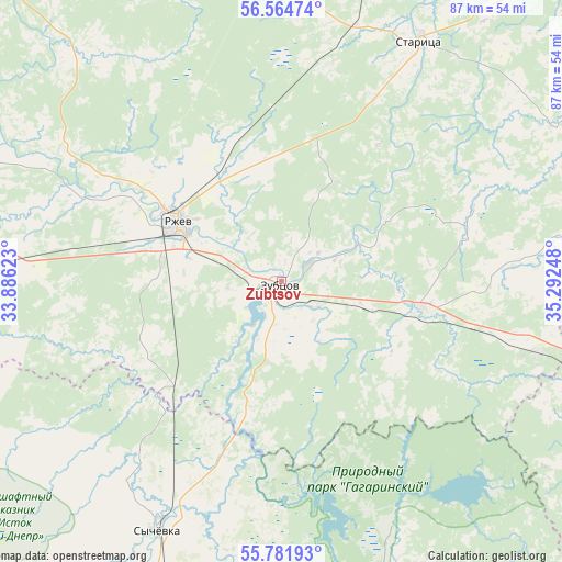
Zubtsov GPS coordinates[2]
56° 10' 31.188" North, 34° 35' 21.66" East
| Map corner | latitude | longitude |
|---|---|---|
| Upper-left | 56.56474°, | 33.88623° |
| Center: | 56.17533°, | 34.58935° |
| Lower-right: | 55.78193°, | 35.29248° |
| Map W x H: | 87×87 km | = 54.1×54.1mi |
| max Lat: | 73.50819° ⇑31.1% North |
| Zubtsov: | 56.17533° |
| min Lat: | ⇓68.9% South 41.28413° |
| min Long | Zubtsov | max Long |
| -179.12198° | 34.58935° | 179.35046° |
| W 10.5%⇐ | ⇒89.5% E |
Elevation
Elevation of Zubtsov is 157 m = 515 ft, and this is 45.6 m = 150 ft below average elevation for this country.
| Max E: |
2518 m = 8261 ft | 44.7% |
| Avg. | 202.6 m = 665 ft | |
| Zubtsov | 157 m = 515 ft | |
Min E: |
-28 m = -92 ft | 55.3% |
See also: Russia elevation on elevation.city.
Geographical zone
Zubtsov is located in North temperate zone (between Tropic of Cancer and the Arctic Circle). Distance of this North polar circle is 1155.1 km =717.7 mi to North.| Distance of | km | miles | from Zubtsov |
|---|---|---|---|
| North Pole | 3761 | 2337 | to North |
| Arctic Circle | 1155.1 | 717.7 | to North |
| Tropic Cancer | 3640.2 | 2261.9 | to South |
| Equator | 6246.1 | 3881.1 | to South |


Nearby cities:
15 places around Zubtsov: (largest is in red/bold)
• Arkhangel’skoye
58.1 km =36.1 mi,  127°
127°
• Bernovo
57.3 km =35.6 mi,  7°
7°
• Gagarin
73.7 km =45.8 mi,  159°
159°
• Knyazh’i Gory
41.3 km =25.7 mi,  105°
105°
• Kur’yanovo
72.6 km =45.1 mi,  103°
103°
• Lotoshino
65.5 km =40.7 mi,  84°
84°
• Mikulino
69.9 km =43.4 mi,  63°
63°
• Novodugino
63.5 km =39.5 mi,  197°
197°
• Olenino
68.2 km =42.4 mi,  273°
273°
• Rzhev
18.8 km =11.7 mi,  300°
300°
• Shakhovskaya
59.1 km =36.7 mi, 105°
• Stantsia Staritsa
41.3 km =25.7 mi,  15°
15°
• Staritsa
42.7 km =26.5 mi,  30°
30°
• Sychëvka
43.6 km =27.1 mi,  206°
206°
• Yaropolets
77.2 km =48 mi,  93°
93°
In other languages:
- In France: Zoubtsov
- In German: Subzow
- In Italian: Zubcov
- In Russian: Зубцов
- In Chinese: 祖布佐夫
Sources, notices
• [Note1] Compared only with cities in Russia existing in our database
• [Src1] Map data: © OpenStreetMap contributors (CC-BY-SA)
• [Src2] Other city data from geonames.org with taken over terms of usage.
• [Src3] Geographical zone / Annual Mean Temperature by Robert A. Rohde @ Wikipedia
