Sychëvka geodata
Sychëvka (Smolensk) is a populated place; located in Russia in Europe/Moscow (GMT+3) time zone. With population of 8,510 people, there are 1718 cities with bigger population in this country. Compared to other cities in Russia, 64% of cities are located further ↓South; 90.1% of cities are located further →East and 69.5% of cities have lower elevation than Sychëvka. Note1


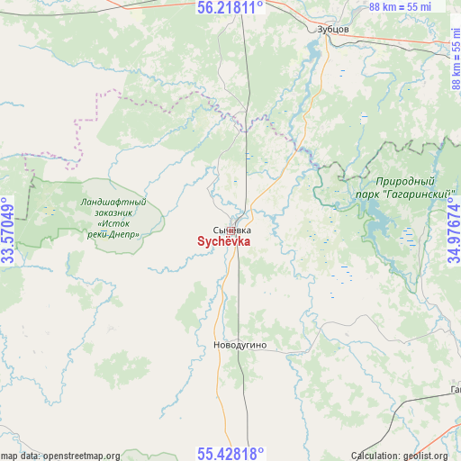
Sychëvka GPS coordinates[2]
55° 49' 30.54" North, 34° 16' 24.996" East
| Map corner | latitude | longitude |
|---|---|---|
| Upper-left | 56.21811°, | 33.57049° |
| Center: | 55.82515°, | 34.27361° |
| Lower-right: | 55.42818°, | 34.97674° |
| Map W x H: | 87.8×87.8 km | = 54.6×54.6mi |
| max Lat: | 73.50819° ⇑36% North |
| Sychëvka: | 55.82515° |
| min Lat: | ⇓64% South 41.28413° |
| min Long | Sychëvka | max Long |
| -179.12198° | 34.27361° | 179.35046° |
| W 9.9%⇐ | ⇒90.1% E |
Elevation
Elevation of Sychëvka is 196 m = 643 ft, and this is 6.6 m = 22 ft below average elevation for this country.
| Max E: |
2518 m = 8261 ft | 30.5% |
| Avg. | 202.6 m = 665 ft | |
| Sychëvka | 196 m = 643 ft | |
Min E: |
-28 m = -92 ft | 69.5% |
See also: Russia elevation on elevation.city.
Geographical zone
Sychëvka is located in North temperate zone (between Tropic of Cancer and the Arctic Circle). Distance of this North polar circle is 1194 km =741.9 mi to North.| Distance of | km | miles | from Sychëvka |
|---|---|---|---|
| North Pole | 3799.9 | 2361.1 | to North |
| Arctic Circle | 1194 | 741.9 | to North |
| Tropic Cancer | 3601.3 | 2237.7 | to South |
| Equator | 6207.2 | 3857 | to South |


Nearby cities:
15 places around Sychëvka: (largest is in red/bold)
• Arkhangel’skoye
66 km =41 mi,  87°
87°
• Belyy
83.2 km =51.7 mi,  271°
271°
• Gagarin
54.4 km =33.8 mi,  123°
123°
• Kholm-Zhirkovskiy
60.7 km =37.7 mi,  235°
235°
• Knyazh’i Gory
66 km =41 mi,  64°
64°
• Novodugino
21.7 km =13.5 mi,  178°
178°
• Olenino
64.8 km =40.3 mi,  311°
311°
• Rzhev
48.7 km =30.3 mi,  3°
3°
• Shakhovskaya
80.2 km =49.8 mi,  73°
73°
• Stantsia Staritsa
84.5 km =52.5 mi,  21°
21°
• Staritsa
86.2 km =53.6 mi,  28°
28°
• Tëmkino
92.3 km =57.4 mi,  149°
149°
• Uvarovka
89.8 km =55.8 mi,  111°
111°
• Vyaz’ma
68.4 km =42.5 mi, 178°
• Zubtsov
43.6 km =27.1 mi, 26°
Sources, notices
• [Note1] Compared only with cities in Russia existing in our database
• [Src1] Map data: © OpenStreetMap contributors (CC-BY-SA)
• [Src2] Other city data from geonames.org with taken over terms of usage.
• [Src3] Geographical zone / Annual Mean Temperature by Robert A. Rohde @ Wikipedia
