Vygonichi geodata
Vygonichi (Bryansk Oblast) is a populated place; located in Russia in Europe/Moscow (GMT+3) time zone. With population of 5,086 people, there are 2619 cities with bigger population in this country. Compared to other cities in Russia, 62.2% of cities are located further ↑North; 90.5% of cities are located further →East and 65.4% of cities have lower elevation than Vygonichi. Note1


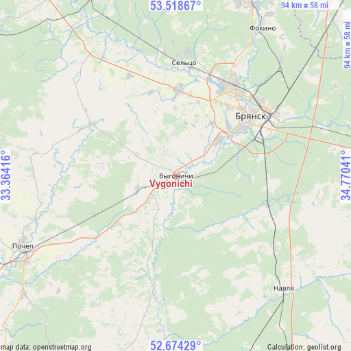
Vygonichi GPS coordinates[2]
53° 5' 54.78" North, 34° 4' 2.208" East
| Map corner | latitude | longitude |
|---|---|---|
| Upper-left | 53.51867°, | 33.36416° |
| Center: | 53.09855°, | 34.06728° |
| Lower-right: | 52.67429°, | 34.77041° |
| Map W x H: | 93.9×93.9 km | = 58.3×58.3mi |
| max Lat: | 73.50819° ⇑62.2% North |
| Vygonichi: | 53.09855° |
| min Lat: | ⇓37.8% South 41.28413° |
| min Long | Vygonichi | max Long |
| -179.12198° | 34.06728° | 179.35046° |
| W 9.5%⇐ | ⇒90.5% E |
Elevation
Elevation of Vygonichi is 183 m = 600 ft, and this is 19.6 m = 64 ft below average elevation for this country.
| Max E: |
2518 m = 8261 ft | 34.6% |
| Avg. | 202.6 m = 665 ft | |
| Vygonichi | 183 m = 600 ft | |
Min E: |
-28 m = -92 ft | 65.4% |
See also: Russia elevation on elevation.city.
Geographical zone
Vygonichi is located in North temperate zone (between Tropic of Cancer and the Arctic Circle). Distance of this North polar circle is 1497.2 km =930.3 mi to North.| Distance of | km | miles | from Vygonichi |
|---|---|---|---|
| North Pole | 4103.1 | 2549.5 | to North |
| Arctic Circle | 1497.2 | 930.3 | to North |
| Tropic Cancer | 3298.1 | 2049.3 | to South |
| Equator | 5904 | 3668.6 | to South |


Nearby cities:
15 places around Vygonichi: (largest is in red/bold)
• Belyye Berega
41.6 km =25.8 mi,  72°
72°
• Bryansk
26.5 km =16.5 mi,  49°
49°
• Dobrun’
15.3 km =9.5 mi, 51°
• Glinishchevo
22.9 km =14.2 mi,  359°
359°
• Ivanovka
29.4 km =18.3 mi,  20°
20°
• Navlya
42 km =26.1 mi,  136°
136°
• Net’inka
28.9 km =18 mi, 16°
• Ovstug
32.5 km =20.2 mi,  336°
336°
• Putëvka
23.1 km =14.4 mi,  39°
39°
• Raditsa-Krylovka
31 km =19.3 mi, 38°
• Rzhanitsa
37.9 km =23.5 mi,  345°
345°
• Sel’tso
30.1 km =18.7 mi,  4°
4°
• Suponevo
19.3 km =12 mi, 52°
• Sven’
33.6 km =20.9 mi, 73°
• Zhiryatino
26.4 km =16.4 mi,  301°
301°
Sources, notices
• [Note1] Compared only with cities in Russia existing in our database
• [Src1] Map data: © OpenStreetMap contributors (CC-BY-SA)
• [Src2] Other city data from geonames.org with taken over terms of usage.
• [Src3] Geographical zone / Annual Mean Temperature by Robert A. Rohde @ Wikipedia
