Rzhanitsa geodata
Rzhanitsa (Bryansk Oblast) is a populated place; located in Russia in Europe/Moscow (GMT+3) time zone. With population of 5,281 people, there are 2517 cities with bigger population in this country. Compared to other cities in Russia, 59.3% of cities are located further ↑North; 90.7% of cities are located further →East and 55.3% of cities have lower elevation than Rzhanitsa. Note1


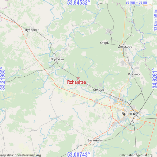
Rzhanitsa GPS coordinates[2]
53° 25' 42.384" North, 33° 55' 22.692" East
| Map corner | latitude | longitude |
|---|---|---|
| Upper-left | 53.84532°, | 33.21985° |
| Center: | 53.42844°, | 33.92297° |
| Lower-right: | 53.00743°, | 34.6261° |
| Map W x H: | 93.2×93.2 km | = 57.9×57.9mi |
| max Lat: | 73.50819° ⇑59.3% North |
| Rzhanitsa: | 53.42844° |
| min Lat: | ⇓40.7% South 41.28413° |
| min Long | Rzhanitsa | max Long |
| -179.12198° | 33.92297° | 179.35046° |
| W 9.3%⇐ | ⇒90.7% E |
Elevation
Elevation of Rzhanitsa is 157 m = 515 ft, and this is 45.6 m = 150 ft below average elevation for this country.
| Max E: |
2518 m = 8261 ft | 44.7% |
| Avg. | 202.6 m = 665 ft | |
| Rzhanitsa | 157 m = 515 ft | |
Min E: |
-28 m = -92 ft | 55.3% |
See also: Russia elevation on elevation.city.
Geographical zone
Rzhanitsa is located in North temperate zone (between Tropic of Cancer and the Arctic Circle). Distance of this North polar circle is 1460.5 km =907.5 mi to North.| Distance of | km | miles | from Rzhanitsa |
|---|---|---|---|
| North Pole | 4066.4 | 2526.7 | to North |
| Arctic Circle | 1460.5 | 907.5 | to North |
| Tropic Cancer | 3334.8 | 2072.1 | to South |
| Equator | 5940.7 | 3691.4 | to South |


Nearby cities:
15 places around Rzhanitsa: (largest is in red/bold)
• Dobrun’
34.5 km =21.4 mi,  141°
141°
• Dyat’kovo
33.3 km =20.7 mi,  55°
55°
• Glinishchevo
16.7 km =10.4 mi,  145°
145°
• Ivanovka
21.6 km =13.4 mi,  114°
114°
• Ivot
32.6 km =20.3 mi,  32°
32°
• Lyubokhna
31.9 km =19.8 mi,  74°
74°
• Net’inka
19.9 km =12.4 mi,  116°
116°
• Ovstug
7.5 km =4.7 mi,  205°
205°
• Putëvka
30.7 km =19.1 mi,  127°
127°
• Raditsa-Krylovka
31.4 km =19.5 mi, 113°
• Sel’tso
13.7 km =8.5 mi, 119°
• Star’
26.5 km =16.5 mi, 34°
• Suponevo
35.1 km =21.8 mi, 135°
• Zhiryatino
26.2 km =16.3 mi, 209°
• Zhukovka
17.4 km =10.8 mi,  312°
312°
Sources, notices
• [Note1] Compared only with cities in Russia existing in our database
• [Src1] Map data: © OpenStreetMap contributors (CC-BY-SA)
• [Src2] Other city data from geonames.org with taken over terms of usage.
• [Src3] Geographical zone / Annual Mean Temperature by Robert A. Rohde @ Wikipedia
