Ekazhevo geodata
Ekazhevo (Ingushetiya Republic) is a populated place; located in Russia in Europe/Moscow (GMT+3) time zone. With population of 25,549 people, there are 740 cities with bigger population in this country. Compared to other cities in Russia, 96.2% of cities are located further ↑North; 50.4% of cities are located further →East and 93.1% of cities have lower elevation than Ekazhevo. Note1


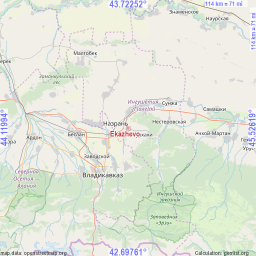
Ekazhevo GPS coordinates[2]
43° 12' 43.992" North, 44° 49' 23.016" East
| Map corner | latitude | longitude |
|---|---|---|
| Upper-left | 43.72252°, | 44.11994° |
| Center: | 43.21222°, | 44.82306° |
| Lower-right: | 42.69761°, | 45.52619° |
| Map W x H: | 114×114 km | = 70.8×70.8mi |
| max Lat: | 73.50819° ⇑96.2% North |
| Ekazhevo: | 43.21222° |
| min Lat: | ⇓3.8% South 41.28413° |
| min Long | Ekazhevo | max Long |
| -179.12198° | 44.82306° | 179.35046° |
| W 49.6%⇐ | ⇒50.4% E |
Elevation
Elevation of Ekazhevo is 541 m = 1775 ft, and this is 338.4 m = 1110 ft above average elevation for this country.
| Max E: |
2518 m = 8261 ft | 6.9% |
| Ekazhevo | 541 m 1775 ft | |
| Avg. | 202.6 m = 665 ft | |
Min E: |
-28 m = -92 ft | 93.1% |
See also: Russia elevation on elevation.city.
Geographical zone
Ekazhevo is located in North temperate zone (between Tropic of Cancer and the Arctic Circle). Distance of this Northern Tropic circle is 2198.8 km =1366.3 mi to South.| Distance of | km | miles | from Ekazhevo |
|---|---|---|---|
| North Pole | 5202.3 | 3232.6 | to North |
| Arctic Circle | 2596.4 | 1613.3 | to North |
| Tropic Cancer | 2198.8 | 1366.3 | to South |
| Equator | 4804.7 | 2985.5 | to South |


Nearby cities:
15 places around Ekazhevo: (largest is in red/bold)
• Ali-Yurt
8.1 km =5 mi,  162°
162°
• Alkhan-Churt
15.8 km =9.8 mi,  349°
349°
• Chermen
11.2 km =7 mi,  233°
233°
• Dachnoye
15.8 km =9.8 mi,  206°
206°
• Galashki
17.2 km =10.7 mi,  127°
127°
• Kambileyevskoye
15.9 km =9.9 mi,  201°
201°
• Kantyshevo
15.5 km =9.6 mi,  276°
276°
• Karabulak
12 km =7.5 mi,  30°
30°
• Magas
4.2 km =2.6 mi,  285°
285°
• Nazran’
4.3 km =2.7 mi, 290°
• Nesterovskaya
18.6 km =11.6 mi,  80°
80°
• Sunzha
17.1 km =10.6 mi,  180°
180°
• Surkhakhi
7 km =4.3 mi,  113°
113°
• Troitskaya
16.7 km =10.4 mi,  51°
51°
• Verkhniye Achaluki
18.1 km =11.2 mi,  325°
325°
Sources, notices
• [Note1] Compared only with cities in Russia existing in our database
• [Src1] Map data: © OpenStreetMap contributors (CC-BY-SA)
• [Src2] Other city data from geonames.org with taken over terms of usage.
• [Src3] Geographical zone / Annual Mean Temperature by Robert A. Rohde @ Wikipedia
