Verkhozim geodata
Verkhozim (Penza) is a populated place; located in Russia in Europe/Moscow (GMT+3) time zone. With population of 1,756 people, there are 4268 cities with bigger population in this country. Compared to other cities in Russia, 64.7% of cities are located further ↑North; 51.2% of cities are located further ←West and 78.1% of cities have lower elevation than Verkhozim. Note1


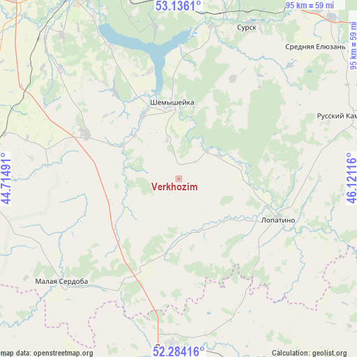
Verkhozim GPS coordinates[2]
52° 42' 43.956" North, 45° 25' 4.908" East
| Map corner | latitude | longitude |
|---|---|---|
| Upper-left | 53.1361°, | 44.71491° |
| Center: | 52.71221°, | 45.41803° |
| Lower-right: | 52.28416°, | 46.12116° |
| Map W x H: | 94.7×94.7 km | = 58.8×58.8mi |
| max Lat: | 73.50819° ⇑64.7% North |
| Verkhozim: | 52.71221° |
| min Lat: | ⇓35.3% South 41.28413° |
| min Long | Verkhozim | max Long |
| -179.12198° | 45.41803° | 179.35046° |
| W 51.2%⇐ | ⇒48.8% E |
Elevation
Elevation of Verkhozim is 235 m = 771 ft, and this is 32.4 m = 106 ft above average elevation for this country.
| Max E: |
2518 m = 8261 ft | 21.9% |
| Verkhozim | 235 m 771 ft | |
| Avg. | 202.6 m = 665 ft | |
Min E: |
-28 m = -92 ft | 78.1% |
See also: Russia elevation on elevation.city.
Geographical zone
Verkhozim is located in North temperate zone (between Tropic of Cancer and the Arctic Circle). Distance of this North polar circle is 1540.1 km =957 mi to North.| Distance of | km | miles | from Verkhozim |
|---|---|---|---|
| North Pole | 4146 | 2576.2 | to North |
| Arctic Circle | 1540.1 | 957 | to North |
| Tropic Cancer | 3255.1 | 2022.6 | to South |
| Equator | 5861 | 3641.9 | to South |


Nearby cities:
15 places around Verkhozim: (largest is in red/bold)
• Chaadayevka
58.2 km =36.2 mi,  34°
34°
• Chemodanovka
58.9 km =36.6 mi,  348°
348°
• Kanayevka
45 km =28 mi,  12°
12°
• Kolyshley
59.4 km =36.9 mi,  268°
268°
• Kondol’
27 km =16.8 mi,  296°
296°
• Lopatino
28.5 km =17.7 mi,  111°
111°
• Malaya Serdoba
41.8 km =26 mi,  229°
229°
• Penza
61 km =37.9 mi,  332°
332°
• Petrovsk
45.2 km =28.1 mi,  182°
182°
• Russkiy Kameshkir
48 km =29.8 mi,  70°
70°
• Shemysheyka
20.1 km =12.5 mi,  355°
355°
• Srednyaya Yelyuzan’
49.9 km =31 mi,  45°
45°
• Sursk
44.2 km =27.5 mi,  23°
23°
• Zarechnyy
56.7 km =35.2 mi,  344°
344°
• Zasechnoye
49.6 km =30.8 mi, 332°
Sources, notices
• [Note1] Compared only with cities in Russia existing in our database
• [Src1] Map data: © OpenStreetMap contributors (CC-BY-SA)
• [Src2] Other city data from geonames.org with taken over terms of usage.
• [Src3] Geographical zone / Annual Mean Temperature by Robert A. Rohde @ Wikipedia
