Ufa geodata
Ufa (Bashkortostan Republic) is a seat of a first-order administrative division; located in Russia in Asia/Yekaterinburg (GMT+5) time zone. With population of 1,033,338 people, there are 10 cities with bigger population in this country. Compared to other cities in Russia, 50.8% of cities are located further ↓South; 67.5% of cities are located further ←West and 55.9% of cities have lower elevation than Ufa. Note1


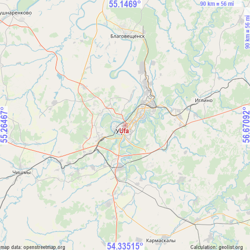
Ufa GPS coordinates[2]
54° 44' 35.016" North, 55° 58' 4.044" East
| Map corner | latitude | longitude |
|---|---|---|
| Upper-left | 55.1469°, | 55.26467° |
| Center: | 54.74306°, | 55.96779° |
| Lower-right: | 54.33515°, | 56.67092° |
| Map W x H: | 90.3×90.3 km | = 56.1×56.1mi |
| max Lat: | 73.50819° ⇑49.2% North |
| Ufa: | 54.74306° |
| min Lat: | ⇓50.8% South 41.28413° |
| min Long | Ufa | max Long |
| -179.12198° | 55.96779° | 179.35046° |
| W 67.5%⇐ | ⇒32.5% E |
Elevation
Elevation of Ufa is 158 m = 518 ft, and this is 44.6 m = 146 ft below average elevation for this country.
| Max E: |
2518 m = 8261 ft | 44.1% |
| Avg. | 202.6 m = 665 ft | |
| Ufa | 158 m = 518 ft | |
Min E: |
-28 m = -92 ft | 55.9% |
See also: Ufa elevation on elevation.city.
Geographical zone
Ufa is located in North temperate zone (between Tropic of Cancer and the Arctic Circle). Distance of this North polar circle is 1314.3 km =816.7 mi to North.| Distance of | km | miles | from Ufa |
|---|---|---|---|
| North Pole | 3920.2 | 2435.9 | to North |
| Arctic Circle | 1314.3 | 816.7 | to North |
| Tropic Cancer | 3480.9 | 2162.9 | to South |
| Equator | 6086.9 | 3782.2 | to South |


Nearby cities:
15 places around Ufa: (largest is in red/bold)
• Alekseyevka
48.6 km =30.2 mi,  284°
284°
• Asanovo
34.9 km =21.7 mi,  298°
298°
• Avdon
18.2 km =11.3 mi,  242°
242°
• Blagoveshchensk
32.5 km =20.2 mi,  1°
1°
• Bulgakovo
27.9 km =17.3 mi,  191°
191°
• Chesnokovka
14.6 km =9.1 mi, 185°
• Chishmy
42.3 km =26.3 mi, 244°
• Dmitriyevka
40.7 km =25.3 mi,  271°
271°
• Iglino
30.2 km =18.8 mi,  70°
70°
• Iskino
25.2 km =15.7 mi, 188°
• Kabakovo
25.8 km =16 mi,  152°
152°
• Karmaskaly
43.7 km =27.2 mi,  161°
161°
• Kudeyevskiy
52.7 km =32.7 mi, 73°
• Mikhaylovka
8.4 km =5.2 mi,  324°
324°
• Ulukulevo
41.1 km =25.5 mi, 146°
Sources, notices
• [Note1] Compared only with cities in Russia existing in our database
• [Src1] Map data: © OpenStreetMap contributors (CC-BY-SA)
• [Src2] Other city data from geonames.org with taken over terms of usage.
• [Src3] Geographical zone / Annual Mean Temperature by Robert A. Rohde @ Wikipedia
