Kabakovo geodata
Kabakovo (Bashkortostan Republic) is a populated place; located in Russia in Asia/Yekaterinburg (GMT+5) time zone. With population of 3,078 people, there are 3714 cities with bigger population in this country. Compared to other cities in Russia, 50.8% of cities are located further ↑North; 67.7% of cities are located further ←West and 71.9% of cities have higher elevation than Kabakovo. Note1


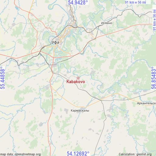
Kabakovo GPS coordinates[2]
54° 32' 12.84" North, 56° 9' 6.12" East
| Map corner | latitude | longitude |
|---|---|---|
| Upper-left | 54.9428°, | 55.44858° |
| Center: | 54.5369°, | 56.1517° |
| Lower-right: | 54.12692°, | 56.85483° |
| Map W x H: | 90.7×90.7 km | = 56.4×56.4mi |
| max Lat: | 73.50819° ⇑50.8% North |
| Kabakovo: | 54.5369° |
| min Lat: | ⇓49.2% South 41.28413° |
| min Long | Kabakovo | max Long |
| -179.12198° | 56.1517° | 179.35046° |
| W 67.7%⇐ | ⇒32.3% E |
Elevation
Elevation of Kabakovo is 98 m = 322 ft, and this is 104.6 m = 343 ft below average elevation for this country.
| Max E: |
2518 m = 8261 ft | 71.9% |
| Avg. | 202.6 m = 665 ft | |
| Kabakovo | 98 m = 322 ft | |
Min E: |
-28 m = -92 ft | 28.1% |
See also: Russia elevation on elevation.city.
Geographical zone
Kabakovo is located in North temperate zone (between Tropic of Cancer and the Arctic Circle). Distance of this North polar circle is 1337.2 km =830.9 mi to North.| Distance of | km | miles | from Kabakovo |
|---|---|---|---|
| North Pole | 3943.1 | 2450.1 | to North |
| Arctic Circle | 1337.2 | 830.9 | to North |
| Tropic Cancer | 3458 | 2148.7 | to South |
| Equator | 6063.9 | 3767.9 | to South |


Nearby cities:
15 places around Kabakovo: (largest is in red/bold)
• Asanovo
58.1 km =36.1 mi,  313°
313°
• Avdon
31.5 km =19.6 mi,  297°
297°
• Blagoveshchensk
56.5 km =35.1 mi,  348°
348°
• Bulgakovo
17.8 km =11.1 mi,  255°
255°
• Chesnokovka
15.7 km =9.8 mi, 302°
• Chishmy
50.2 km =31.2 mi,  275°
275°
• Dmitriyevka
57.7 km =35.9 mi,  294°
294°
• Iglino
36.9 km =22.9 mi,  27°
27°
• Iskino
15.7 km =9.8 mi, 262°
• Karmaskaly
18.6 km =11.6 mi,  173°
173°
• Kudeyevskiy
54.1 km =33.6 mi,  45°
45°
• Mikhaylovka
34.2 km =21.3 mi,  330°
330°
• Tolbazy
59.6 km =37 mi,  197°
197°
• Ufa
25.8 km =16 mi, 332°
• Ulukulevo
15.8 km =9.8 mi,  135°
135°
Sources, notices
• [Note1] Compared only with cities in Russia existing in our database
• [Src1] Map data: © OpenStreetMap contributors (CC-BY-SA)
• [Src2] Other city data from geonames.org with taken over terms of usage.
• [Src3] Geographical zone / Annual Mean Temperature by Robert A. Rohde @ Wikipedia
