Temizhbekskaya geodata
Temizhbekskaya (Krasnodarskiy) is a populated place; located in Russia in Europe/Moscow (GMT+3) time zone. With population of 6,111 people, there are 2227 cities with bigger population in this country. Compared to other cities in Russia, 85.4% of cities are located further ↑North; 63.7% of cities are located further →East and 61.4% of cities have higher elevation than Temizhbekskaya. Note1


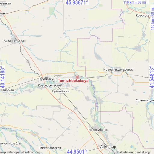
Temizhbekskaya GPS coordinates[2]
45° 26' 44.016" North, 40° 50' 42" East
| Map corner | latitude | longitude |
|---|---|---|
| Upper-left | 45.93671°, | 40.14188° |
| Center: | 45.44556°, | 40.845° |
| Lower-right: | 44.9501°, | 41.54813° |
| Map W x H: | 109.7×109.7 km | = 68.2×68.2mi |
| max Lat: | 73.50819° ⇑85.4% North |
| Temizhbekskaya: | 45.44556° |
| min Lat: | ⇓14.6% South 41.28413° |
| min Long | Temizhbekskaya | max Long |
| -179.12198° | 40.845° | 179.35046° |
| W 36.3%⇐ | ⇒63.7% E |
Elevation
Elevation of Temizhbekskaya is 121 m = 397 ft, and this is 81.6 m = 268 ft below average elevation for this country.
| Max E: |
2518 m = 8261 ft | 61.4% |
| Avg. | 202.6 m = 665 ft | |
| Temizhbekskaya | 121 m = 397 ft | |
Min E: |
-28 m = -92 ft | 38.6% |
See also: Russia elevation on elevation.city.
Geographical zone
Temizhbekskaya is located in North temperate zone (between Tropic of Cancer and the Arctic Circle). Distance of this North polar circle is 2348.1 km =1459 mi to North.| Distance of | km | miles | from Temizhbekskaya |
|---|---|---|---|
| North Pole | 4954 | 3078.3 | to North |
| Arctic Circle | 2348.1 | 1459 | to North |
| Tropic Cancer | 2447.2 | 1520.6 | to South |
| Equator | 5053.1 | 3139.8 | to South |


Nearby cities:
15 places around Temizhbekskaya: (largest is in red/bold)
• Dmitriyevskaya
24.2 km =15 mi,  345°
345°
• Girey
15.4 km =9.6 mi,  251°
251°
• Grigoropolisskaya
23.4 km =14.5 mi,  134°
134°
• Gul’kevichi
15.6 km =9.7 mi,  229°
229°
• Kavkazskaya
13.1 km =8.1 mi,  269°
269°
• Kovalevskoye
29.8 km =18.5 mi,  159°
159°
• Kropotkin
21 km =13 mi, 267°
• Maykopskoye
8.5 km =5.3 mi, 226°
• Novoaleksandrovsk
29.8 km =18.5 mi,  79°
79°
• Novoukrainskoye
25.7 km =16 mi, 253°
• Otrado-Kubanskoye
22.4 km =13.9 mi,  180°
180°
• Rasshevatskaya
20.6 km =12.8 mi,  45°
45°
• Sokolovskoye
24.5 km =15.2 mi,  211°
211°
• Temizhbekskaya
15.1 km =9.4 mi,  87°
87°
• Ventsy
7.7 km =4.8 mi,  185°
185°
Sources, notices
• [Note1] Compared only with cities in Russia existing in our database
• [Src1] Map data: © OpenStreetMap contributors (CC-BY-SA)
• [Src2] Other city data from geonames.org with taken over terms of usage.
• [Src3] Geographical zone / Annual Mean Temperature by Robert A. Rohde @ Wikipedia
