Novoaleksandrovsk geodata
Novoaleksandrovsk (Stavropol’ Kray) is a populated place; located in Russia in Europe/Moscow (GMT+3) time zone. With population of 27,610 people, there are 709 cities with bigger population in this country. Compared to other cities in Russia, 85.2% of cities are located further ↑North; 62.3% of cities are located further →East and 70.6% of cities have higher elevation than Novoaleksandrovsk. Note1


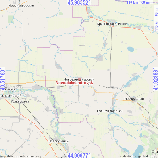
Novoaleksandrovsk GPS coordinates[2]
45° 29' 41.28" North, 41° 13' 14.7" East
| Map corner | latitude | longitude |
|---|---|---|
| Upper-left | 45.98552°, | 40.51763° |
| Center: | 45.4948°, | 41.22075° |
| Lower-right: | 44.99977°, | 41.92388° |
| Map W x H: | 109.6×109.6 km | = 68.1×68.1mi |
| max Lat: | 73.50819° ⇑85.2% North |
| Novoaleksandrovsk: | 45.4948° |
| min Lat: | ⇓14.8% South 41.28413° |
| min Long | Novoaleksandrov | max Long |
| -179.12198° | 41.22075° | 179.35046° |
| W 37.7%⇐ | ⇒62.3% E |
Elevation
Elevation of Novoaleksandrovsk is 101 m = 331 ft, and this is 101.6 m = 333 ft below average elevation for this country.
| Max E: |
2518 m = 8261 ft | 70.6% |
| Avg. | 202.6 m = 665 ft | |
| Novoaleksandrovsk | 101 m = 331 ft | |
Min E: |
-28 m = -92 ft | 29.4% |
See also: Russia elevation on elevation.city.
Geographical zone
Novoaleksandrovsk is located in North temperate zone (between Tropic of Cancer and the Arctic Circle). Distance of this North polar circle is 2342.6 km =1455.6 mi to North.| Distance of | km | miles | from Novoaleksandrovsk |
|---|---|---|---|
| North Pole | 4948.5 | 3074.9 | to North |
| Arctic Circle | 2342.6 | 1455.6 | to North |
| Tropic Cancer | 2452.6 | 1524 | to South |
| Equator | 5058.5 | 3143.2 | to South |


Nearby cities:
15 places around Novoaleksandrovsk: (largest is in red/bold)
• Dmitriyevskaya
39.7 km =24.7 mi,  296°
296°
• Grigoropolisskaya
25.4 km =15.8 mi,  210°
210°
• Izobil’nyy
40.5 km =25.2 mi,  109°
109°
• Kavkazskaya
42.8 km =26.6 mi,  262°
262°
• Kovalevskoye
38.5 km =23.9 mi, 209°
• Ladovskaya Balka
20.6 km =12.8 mi,  43°
43°
• Maykopskoye
37.2 km =23.1 mi,  252°
252°
• Novotroitskaya
30.2 km =18.8 mi,  128°
128°
• Otrado-Kubanskoye
40.7 km =25.3 mi,  226°
226°
• Rasshevatskaya
17 km =10.6 mi, 301°
• Temizhbekskaya
15 km =9.3 mi, 250°
• Temizhbekskaya
29.8 km =18.5 mi, 259°
• Tishchenskoye
35.5 km =22.1 mi,  96°
96°
• Uspenskaya
32.3 km =20.1 mi,  338°
338°
• Ventsy
32.8 km =20.4 mi, 246°
Sources, notices
• [Note1] Compared only with cities in Russia existing in our database
• [Src1] Map data: © OpenStreetMap contributors (CC-BY-SA)
• [Src2] Other city data from geonames.org with taken over terms of usage.
• [Src3] Geographical zone / Annual Mean Temperature by Robert A. Rohde @ Wikipedia
