Sokolovskoye geodata
Sokolovskoye (Krasnodarskiy) is a populated place; located in Russia in Europe/Moscow (GMT+3) time zone. With population of 3,138 people, there are 3663 cities with bigger population in this country. Compared to other cities in Russia, 86.2% of cities are located further ↑North; 64.3% of cities are located further →East and 63.9% of cities have higher elevation than Sokolovskoye. Note1


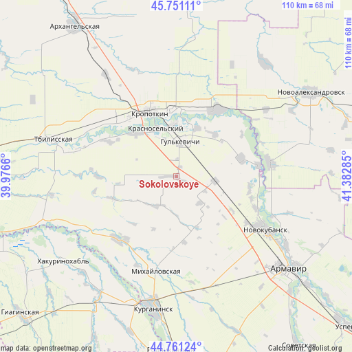
Sokolovskoye GPS coordinates[2]
45° 15' 29.988" North, 40° 40' 46.992" East
| Map corner | latitude | longitude |
|---|---|---|
| Upper-left | 45.75111°, | 39.9766° |
| Center: | 45.25833°, | 40.67972° |
| Lower-right: | 44.76124°, | 41.38285° |
| Map W x H: | 110.1×110.1 km | = 68.4×68.4mi |
| max Lat: | 73.50819° ⇑86.2% North |
| Sokolovskoye: | 45.25833° |
| min Lat: | ⇓13.8% South 41.28413° |
| min Long | Sokolovskoye | max Long |
| -179.12198° | 40.67972° | 179.35046° |
| W 35.7%⇐ | ⇒64.3% E |
Elevation
Elevation of Sokolovskoye is 116 m = 381 ft, and this is 86.6 m = 284 ft below average elevation for this country.
| Max E: |
2518 m = 8261 ft | 63.9% |
| Avg. | 202.6 m = 665 ft | |
| Sokolovskoye | 116 m = 381 ft | |
Min E: |
-28 m = -92 ft | 36.1% |
See also: Russia elevation on elevation.city.
Geographical zone
Sokolovskoye is located in North temperate zone (between Tropic of Cancer and the Arctic Circle). Distance of this North polar circle is 2368.9 km =1472 mi to North.| Distance of | km | miles | from Sokolovskoye |
|---|---|---|---|
| North Pole | 4974.8 | 3091.2 | to North |
| Arctic Circle | 2368.9 | 1472 | to North |
| Tropic Cancer | 2426.3 | 1507.6 | to South |
| Equator | 5032.3 | 3126.9 | to South |


Nearby cities:
15 places around Sokolovskoye: (largest is in red/bold)
• Girey
16 km =9.9 mi,  354°
354°
• Grigoropolisskaya
29.8 km =18.5 mi,  81°
81°
• Gul’kevichi
10.7 km =6.6 mi,  6°
6°
• Kavkazskaya
20.8 km =12.9 mi,  359°
359°
• Kazanskaya
25.5 km =15.8 mi,  311°
311°
• Kovalevskoye
24.3 km =15.1 mi,  107°
107°
• Kropotkin
21.5 km =13.4 mi,  337°
337°
• Maykopskoye
16.5 km =10.3 mi,  24°
24°
• Mikhaylovskaya
30 km =18.6 mi,  192°
192°
• Novokubansk
31.4 km =19.5 mi,  120°
120°
• Novoukrainskoye
17.8 km =11.1 mi,  318°
318°
• Otrado-Kubanskoye
12.7 km =7.9 mi,  97°
97°
• Petropavlovskaya
26.6 km =16.5 mi,  222°
222°
• Temizhbekskaya
24.5 km =15.2 mi,  31°
31°
• Ventsy
17.9 km =11.1 mi,  42°
42°
Sources, notices
• [Note1] Compared only with cities in Russia existing in our database
• [Src1] Map data: © OpenStreetMap contributors (CC-BY-SA)
• [Src2] Other city data from geonames.org with taken over terms of usage.
• [Src3] Geographical zone / Annual Mean Temperature by Robert A. Rohde @ Wikipedia
