Sukhobezvodnoye geodata
Sukhobezvodnoye (Nizhny Novgorod Oblast) is a populated place; located in Russia in Europe/Moscow (GMT+3) time zone. With population of 5,970 people, there are 2265 cities with bigger population in this country. Compared to other cities in Russia, 77.7% of cities are located further ↓South; 50.2% of cities are located further →East and 52.4% of cities have lower elevation than Sukhobezvodnoye. Note1


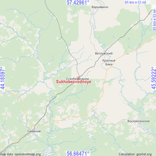
Sukhobezvodnoye GPS coordinates[2]
57° 2' 56.868" North, 44° 53' 20.724" East
| Map corner | latitude | longitude |
|---|---|---|
| Upper-left | 57.42961°, | 44.18597° |
| Center: | 57.04913°, | 44.88909° |
| Lower-right: | 56.66471°, | 45.59222° |
| Map W x H: | 85×85 km | = 52.8×52.8mi |
| max Lat: | 73.50819° ⇑22.3% North |
| Sukhobezvodnoye: | 57.04913° |
| min Lat: | ⇓77.7% South 41.28413° |
| min Long | Sukhobezvodnoye | max Long |
| -179.12198° | 44.88909° | 179.35046° |
| W 49.8%⇐ | ⇒50.2% E |
Elevation
Elevation of Sukhobezvodnoye is 150 m = 492 ft, and this is 52.6 m = 173 ft below average elevation for this country.
| Max E: |
2518 m = 8261 ft | 47.6% |
| Avg. | 202.6 m = 665 ft | |
| Sukhobezvodnoye | 150 m = 492 ft | |
Min E: |
-28 m = -92 ft | 52.4% |
See also: Russia elevation on elevation.city.
Geographical zone
Sukhobezvodnoye is located in North temperate zone (between Tropic of Cancer and the Arctic Circle). Distance of this North polar circle is 1057.9 km =657.3 mi to North.| Distance of | km | miles | from Sukhobezvodnoye |
|---|---|---|---|
| North Pole | 3663.8 | 2276.6 | to North |
| Arctic Circle | 1057.9 | 657.3 | to North |
| Tropic Cancer | 3737.3 | 2322.2 | to South |
| Equator | 6343.3 | 3941.5 | to South |


Nearby cities:
15 places around Sukhobezvodnoye: (largest is in red/bold)
• Ar’ya
81.3 km =50.5 mi,  52°
52°
• Bol’sheorlovskiy
71.8 km =44.6 mi,  194°
194°
• Bor
91.5 km =56.9 mi,  212°
212°
• Kerzhenets
70.6 km =43.9 mi,  203°
203°
• Kovernino
65.6 km =40.8 mi,  277°
277°
• Krasnyye Baki
18.7 km =11.6 mi,  60°
60°
• Linda
68.2 km =42.4 mi,  225°
225°
• Neklyudovo
89.9 km =55.9 mi,  218°
218°
• Semënov
37.7 km =23.4 mi, 219°
• Sitniki
82.9 km =51.5 mi, 217°
• Uren’
70.3 km =43.7 mi, 50°
• Varnavino
41.2 km =25.6 mi,  17°
17°
• Vetluzhskiy
19.8 km =12.3 mi, 45°
• Vladimirskoye
29 km =18 mi,  151°
151°
• Voskresenskoye
40.4 km =25.1 mi,  125°
125°
Sources, notices
• [Note1] Compared only with cities in Russia existing in our database
• [Src1] Map data: © OpenStreetMap contributors (CC-BY-SA)
• [Src2] Other city data from geonames.org with taken over terms of usage.
• [Src3] Geographical zone / Annual Mean Temperature by Robert A. Rohde @ Wikipedia
