Zemlyansk geodata
Zemlyansk (Voronezj) is a populated place; located in Russia in Europe/Moscow (GMT+3) time zone. With population of 3,111 people, there are 3683 cities with bigger population in this country. Compared to other cities in Russia, 69.7% of cities are located further ↑North; 73.4% of cities are located further →East and 66.5% of cities have lower elevation than Zemlyansk. Note1


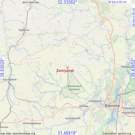
Zemlyansk GPS coordinates[2]
51° 54' 14.76" North, 38° 44' 0.24" East
| Map corner | latitude | longitude |
|---|---|---|
| Upper-left | 52.33582°, | 38.03028° |
| Center: | 51.9041°, | 38.7334° |
| Lower-right: | 51.46819°, | 39.43653° |
| Map W x H: | 96.5×96.5 km | = 60×60mi |
| max Lat: | 73.50819° ⇑69.7% North |
| Zemlyansk: | 51.9041° |
| min Lat: | ⇓30.3% South 41.28413° |
| min Long | Zemlyansk | max Long |
| -179.12198° | 38.7334° | 179.35046° |
| W 26.6%⇐ | ⇒73.4% E |
Elevation
Elevation of Zemlyansk is 186 m = 610 ft, and this is 16.6 m = 54 ft below average elevation for this country.
| Max E: |
2518 m = 8261 ft | 33.5% |
| Avg. | 202.6 m = 665 ft | |
| Zemlyansk | 186 m = 610 ft | |
Min E: |
-28 m = -92 ft | 66.5% |
See also: Russia elevation on elevation.city.
Geographical zone
Zemlyansk is located in North temperate zone (between Tropic of Cancer and the Arctic Circle). Distance of this North polar circle is 1630 km =1012.8 mi to North.| Distance of | km | miles | from Zemlyansk |
|---|---|---|---|
| North Pole | 4235.9 | 2632.1 | to North |
| Arctic Circle | 1630 | 1012.8 | to North |
| Tropic Cancer | 3165.3 | 1966.8 | to South |
| Equator | 5771.2 | 3586.1 | to South |


Nearby cities:
15 places around Zemlyansk: (largest is in red/bold)
• Devitsa
33.3 km =20.7 mi,  154°
154°
• Kastornoye
42.2 km =26.2 mi,  259°
259°
• Khlevnoye
40.6 km =25.2 mi,  37°
37°
• Latnaya
29.6 km =18.4 mi,  157°
157°
• Novozhivotinnoye
29.9 km =18.6 mi,  93°
93°
• Olym
45.7 km =28.4 mi,  236°
236°
• Podgornoye
34.2 km =21.3 mi,  123°
123°
• Pridonskoy
33.8 km =21 mi,  136°
136°
• Ramon’
41.4 km =25.7 mi, 88°
• Semiluki
31.7 km =19.7 mi, 140°
• Shilovo
46.8 km =29.1 mi, 148°
• Somovo
47.1 km =29.3 mi,  112°
112°
• Strelitsa
35.1 km =21.8 mi, 159°
• Terbuny
41.1 km =25.5 mi,  311°
311°
• Voronezh
40.3 km =25 mi,  129°
129°
Sources, notices
• [Note1] Compared only with cities in Russia existing in our database
• [Src1] Map data: © OpenStreetMap contributors (CC-BY-SA)
• [Src2] Other city data from geonames.org with taken over terms of usage.
• [Src3] Geographical zone / Annual Mean Temperature by Robert A. Rohde @ Wikipedia
