Starozhilovo geodata
Starozhilovo (Ryazan Oblast) is a populated place; located in Russia in Europe/Moscow (GMT+3) time zone. With population of 5,147 people, there are 2583 cities with bigger population in this country. Compared to other cities in Russia, 53.2% of cities are located further ↑North; 67.9% of cities are located further →East and 57.7% of cities have higher elevation than Starozhilovo. Note1


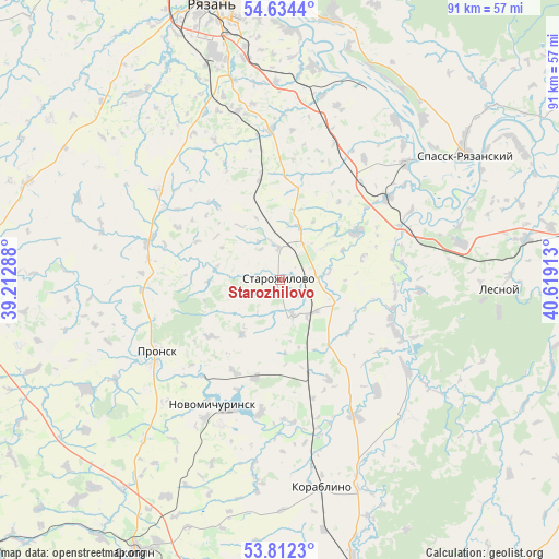
Starozhilovo GPS coordinates[2]
54° 13' 31.44" North, 39° 54' 57.6" East
| Map corner | latitude | longitude |
|---|---|---|
| Upper-left | 54.6344°, | 39.21288° |
| Center: | 54.2254°, | 39.916° |
| Lower-right: | 53.8123°, | 40.61913° |
| Map W x H: | 91.4×91.4 km | = 56.8×56.8mi |
| max Lat: | 73.50819° ⇑53.2% North |
| Starozhilovo: | 54.2254° |
| min Lat: | ⇓46.8% South 41.28413° |
| min Long | Starozhilovo | max Long |
| -179.12198° | 39.916° | 179.35046° |
| W 32.1%⇐ | ⇒67.9% E |
Elevation
Elevation of Starozhilovo is 129 m = 423 ft, and this is 73.6 m = 241 ft below average elevation for this country.
| Max E: |
2518 m = 8261 ft | 57.7% |
| Avg. | 202.6 m = 665 ft | |
| Starozhilovo | 129 m = 423 ft | |
Min E: |
-28 m = -92 ft | 42.3% |
See also: Russia elevation on elevation.city.
Geographical zone
Starozhilovo is located in North temperate zone (between Tropic of Cancer and the Arctic Circle). Distance of this North polar circle is 1371.9 km =852.5 mi to North.| Distance of | km | miles | from Starozhilovo |
|---|---|---|---|
| North Pole | 3977.8 | 2471.7 | to North |
| Arctic Circle | 1371.9 | 852.5 | to North |
| Tropic Cancer | 3423.4 | 2127.2 | to South |
| Equator | 6029.3 | 3746.4 | to South |


Nearby cities:
15 places around Starozhilovo: (largest is in red/bold)
• Kiritsy
29.4 km =18.3 mi,  76°
76°
• Korablino
34.9 km =21.7 mi,  169°
169°
• Lesnoy
36.1 km =22.4 mi,  92°
92°
• Mikhaylov
57.8 km =35.9 mi,  270°
270°
• Murmino
43.1 km =26.8 mi,  12°
12°
• Novomichurinsk
23.5 km =14.6 mi,  207°
207°
• Polyany
55.1 km =34.2 mi,  354°
354°
• Pronsk
24.1 km =15 mi,  236°
236°
• Ryazan’
46.9 km =29.1 mi,  341°
341°
• Ryazhsk
59.4 km =36.9 mi, 167°
• Sapozhok
59 km =36.7 mi,  122°
122°
• Skopin
50.5 km =31.4 mi, 208°
• Spassk-Ryazanskiy
35.9 km =22.3 mi,  56°
56°
• Zakharovo
44.2 km =27.5 mi,  290°
290°
• Zarechnyy
58.9 km =36.6 mi,  200°
200°
Sources, notices
• [Note1] Compared only with cities in Russia existing in our database
• [Src1] Map data: © OpenStreetMap contributors (CC-BY-SA)
• [Src2] Other city data from geonames.org with taken over terms of usage.
• [Src3] Geographical zone / Annual Mean Temperature by Robert A. Rohde @ Wikipedia
