Spassk-Ryazanskiy geodata
Spassk-Ryazanskiy (Ryazan Oblast) is a populated place; located in Russia in Europe/Moscow (GMT+3) time zone. With population of 8,655 people, there are 1698 cities with bigger population in this country. Compared to other cities in Russia, 51.9% of cities are located further ↑North; 65.7% of cities are located further →East and 66% of cities have higher elevation than Spassk-Ryazanskiy. Note1


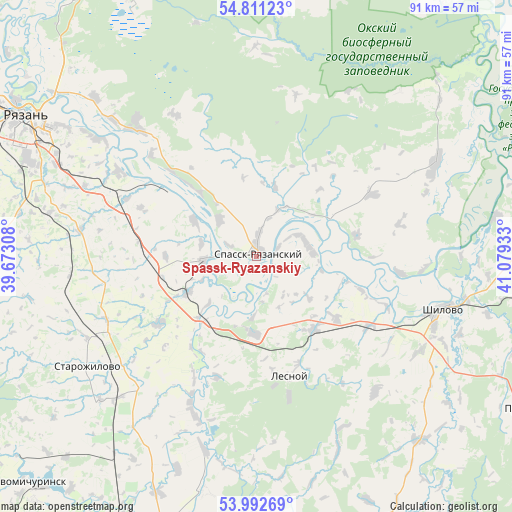
Spassk-Ryazanskiy GPS coordinates[2]
54° 24' 14.4" North, 40° 22' 34.32" East
| Map corner | latitude | longitude |
|---|---|---|
| Upper-left | 54.81123°, | 39.67308° |
| Center: | 54.404°, | 40.3762° |
| Lower-right: | 53.99269°, | 41.07933° |
| Map W x H: | 91×91 km | = 56.5×56.5mi |
| max Lat: | 73.50819° ⇑51.9% North |
| Spassk-Ryazanskiy: | 54.404° |
| min Lat: | ⇓48.1% South 41.28413° |
| min Long | Spassk-Ryazansk | max Long |
| -179.12198° | 40.3762° | 179.35046° |
| W 34.3%⇐ | ⇒65.7% E |
Elevation
Elevation of Spassk-Ryazanskiy is 111 m = 364 ft, and this is 91.6 m = 301 ft below average elevation for this country.
| Max E: |
2518 m = 8261 ft | 66% |
| Avg. | 202.6 m = 665 ft | |
| Spassk-Ryazanskiy | 111 m = 364 ft | |
Min E: |
-28 m = -92 ft | 34% |
See also: Russia elevation on elevation.city.
Geographical zone
Spassk-Ryazanskiy is located in North temperate zone (between Tropic of Cancer and the Arctic Circle). Distance of this North polar circle is 1352 km =840.1 mi to North.| Distance of | km | miles | from Spassk-Ryazanskiy |
|---|---|---|---|
| North Pole | 3957.9 | 2459.3 | to North |
| Arctic Circle | 1352 | 840.1 | to North |
| Tropic Cancer | 3443.2 | 2139.5 | to South |
| Equator | 6049.2 | 3758.8 | to South |


Nearby cities:
15 places around Spassk-Ryazanskiy: (largest is in red/bold)
• Izhevskoye
36.5 km =22.7 mi,  62°
62°
• Kiritsy
13.2 km =8.2 mi,  185°
185°
• Korablino
59.1 km =36.7 mi,  203°
203°
• Lesnoy
22.2 km =13.8 mi,  163°
163°
• Morozovy-Borki
60.8 km =37.8 mi,  144°
144°
• Murmino
30.4 km =18.9 mi,  317°
317°
• Novomichurinsk
57.6 km =35.8 mi,  225°
225°
• Polyany
49.6 km =30.8 mi,  314°
314°
• Pronsk
59.9 km =37.2 mi,  236°
236°
• Putyatino
55.2 km =34.3 mi,  119°
119°
• Ryazan’
50.7 km =31.5 mi,  299°
299°
• Sapozhok
55.1 km =34.2 mi, 158°
• Shilovo
33.6 km =20.9 mi,  106°
106°
• Solotcha
55.3 km =34.4 mi, 320°
• Starozhilovo
35.9 km =22.3 mi, 236°
Sources, notices
• [Note1] Compared only with cities in Russia existing in our database
• [Src1] Map data: © OpenStreetMap contributors (CC-BY-SA)
• [Src2] Other city data from geonames.org with taken over terms of usage.
• [Src3] Geographical zone / Annual Mean Temperature by Robert A. Rohde @ Wikipedia
