Novomichurinsk geodata
Novomichurinsk (Ryazan Oblast) is a populated place; located in Russia in Europe/Moscow (GMT+3) time zone. With population of 20,821 people, there are 841 cities with bigger population in this country. Compared to other cities in Russia, 54.9% of cities are located further ↑North; 68.8% of cities are located further →East and 62.5% of cities have higher elevation than Novomichurinsk. Note1


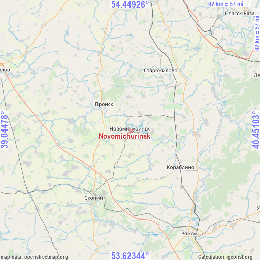
Novomichurinsk GPS coordinates[2]
54° 2' 18.24" North, 39° 44' 52.44" East
| Map corner | latitude | longitude |
|---|---|---|
| Upper-left | 54.44926°, | 39.04478° |
| Center: | 54.0384°, | 39.7479° |
| Lower-right: | 53.62344°, | 40.45103° |
| Map W x H: | 91.8×91.8 km | = 57×57mi |
| max Lat: | 73.50819° ⇑54.9% North |
| Novomichurinsk: | 54.0384° |
| min Lat: | ⇓45.1% South 41.28413° |
| min Long | Novomichurinsk | max Long |
| -179.12198° | 39.7479° | 179.35046° |
| W 31.2%⇐ | ⇒68.8% E |
Elevation
Elevation of Novomichurinsk is 119 m = 390 ft, and this is 83.6 m = 274 ft below average elevation for this country.
| Max E: |
2518 m = 8261 ft | 62.5% |
| Avg. | 202.6 m = 665 ft | |
| Novomichurinsk | 119 m = 390 ft | |
Min E: |
-28 m = -92 ft | 37.5% |
See also: Russia elevation on elevation.city.
Geographical zone
Novomichurinsk is located in North temperate zone (between Tropic of Cancer and the Arctic Circle). Distance of this North polar circle is 1392.7 km =865.4 mi to North.| Distance of | km | miles | from Novomichurinsk |
|---|---|---|---|
| North Pole | 3998.6 | 2484.6 | to North |
| Arctic Circle | 1392.7 | 865.4 | to North |
| Tropic Cancer | 3402.6 | 2114.3 | to South |
| Equator | 6008.5 | 3733.5 | to South |


Nearby cities:
15 places around Novomichurinsk: (largest is in red/bold)
• Kiritsy
48.3 km =30 mi,  55°
55°
• Korablino
22 km =13.7 mi,  128°
128°
• Lesnoy
51 km =31.7 mi,  67°
67°
• Mikhaylov
51.6 km =32.1 mi,  294°
294°
• Miloslavskoye
54.7 km =34 mi,  201°
201°
• Pavelets
43.1 km =26.8 mi,  229°
229°
• Poplevinskiy
41.5 km =25.8 mi, 198°
• Pronsk
11.7 km =7.3 mi,  309°
309°
• Ryazhsk
44.2 km =27.5 mi,  147°
147°
• Skopin
27 km =16.8 mi,  208°
208°
• Spassk-Ryazanskiy
57.6 km =35.8 mi,  45°
45°
• Starozhilovo
23.5 km =14.6 mi,  27°
27°
• Ukholovo
55.7 km =34.6 mi,  119°
119°
• Zakharovo
47.5 km =29.5 mi,  320°
320°
• Zarechnyy
35.7 km =22.2 mi, 196°
Sources, notices
• [Note1] Compared only with cities in Russia existing in our database
• [Src1] Map data: © OpenStreetMap contributors (CC-BY-SA)
• [Src2] Other city data from geonames.org with taken over terms of usage.
• [Src3] Geographical zone / Annual Mean Temperature by Robert A. Rohde @ Wikipedia
