Staroutkinsk geodata
Staroutkinsk (Sverdlovsk) is a populated place; located in Russia in Asia/Yekaterinburg (GMT+5) time zone. With population of 3,188 people, there are 3617 cities with bigger population in this country. Compared to other cities in Russia, 78.6% of cities are located further ↓South; 70.6% of cities are located further ←West and 82.1% of cities have lower elevation than Staroutkinsk. Note1


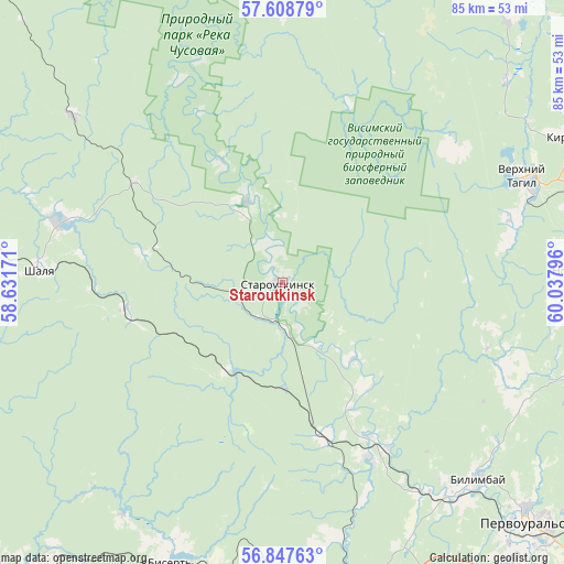
Staroutkinsk GPS coordinates[2]
57° 13' 48.612" North, 59° 20' 5.388" East
| Map corner | latitude | longitude |
|---|---|---|
| Upper-left | 57.60879°, | 58.63171° |
| Center: | 57.23017°, | 59.33483° |
| Lower-right: | 56.84763°, | 60.03796° |
| Map W x H: | 84.6×84.6 km | = 52.6×52.6mi |
| max Lat: | 73.50819° ⇑21.4% North |
| Staroutkinsk: | 57.23017° |
| min Lat: | ⇓78.6% South 41.28413° |
| min Long | Staroutkinsk | max Long |
| -179.12198° | 59.33483° | 179.35046° |
| W 70.6%⇐ | ⇒29.4% E |
Elevation
Elevation of Staroutkinsk is 275 m = 902 ft, and this is 72.4 m = 238 ft above average elevation for this country.
| Max E: |
2518 m = 8261 ft | 17.9% |
| Staroutkinsk | 275 m 902 ft | |
| Avg. | 202.6 m = 665 ft | |
Min E: |
-28 m = -92 ft | 82.1% |
See also: Russia elevation on elevation.city.
Geographical zone
Staroutkinsk is located in North temperate zone (between Tropic of Cancer and the Arctic Circle). Distance of this North polar circle is 1037.8 km =644.9 mi to North.| Distance of | km | miles | from Staroutkinsk |
|---|---|---|---|
| North Pole | 3643.7 | 2264.1 | to North |
| Arctic Circle | 1037.8 | 644.9 | to North |
| Tropic Cancer | 3757.5 | 2334.8 | to South |
| Equator | 6363.4 | 3954 | to South |


Nearby cities:
15 places around Staroutkinsk: (largest is in red/bold)
• Bilimbay
41 km =25.5 mi,  135°
135°
• Bisert’
44.4 km =27.6 mi,  202°
202°
• Druzhinino
50.2 km =31.2 mi,  167°
167°
• Kalinovo
50.1 km =31.1 mi,  102°
102°
• Karpushikha
45.2 km =28.1 mi,  48°
48°
• Kirovgrad
48.8 km =30.3 mi,  62°
62°
• Kuzino
24 km =14.9 mi,  164°
164°
• Neyvo-Rudyanka
49.7 km =30.9 mi,  75°
75°
• Novoural’sk
45.1 km =28 mi,  88°
88°
• Novoutkinsk
29.6 km =18.4 mi,  153°
153°
• Shalya
36.5 km =22.7 mi,  272°
272°
• Sylva
34.9 km =21.7 mi,  284°
284°
• Verkh-Neyvinskiy
48.5 km =30.1 mi, 84°
• Verkhniy Tagil
40.5 km =25.2 mi,  66°
66°
• Visim
47.6 km =29.6 mi,  12°
12°
Sources, notices
• [Note1] Compared only with cities in Russia existing in our database
• [Src1] Map data: © OpenStreetMap contributors (CC-BY-SA)
• [Src2] Other city data from geonames.org with taken over terms of usage.
• [Src3] Geographical zone / Annual Mean Temperature by Robert A. Rohde @ Wikipedia
