Kirovgrad geodata
Kirovgrad (Sverdlovsk) is a populated place; located in Russia in Asia/Yekaterinburg (GMT+5) time zone. With population of 22,685 people, there are 799 cities with bigger population in this country. Compared to other cities in Russia, 79.7% of cities are located further ↓South; 71.7% of cities are located further ←West and 83% of cities have lower elevation than Kirovgrad. Note1


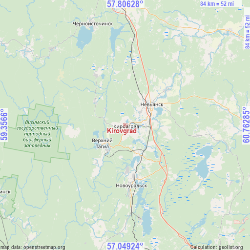
Kirovgrad GPS coordinates[2]
57° 25' 46.992" North, 60° 3' 34.992" East
| Map corner | latitude | longitude |
|---|---|---|
| Upper-left | 57.80628°, | 59.3566° |
| Center: | 57.42972°, | 60.05972° |
| Lower-right: | 57.04924°, | 60.76285° |
| Map W x H: | 84.2×84.2 km | = 52.3×52.3mi |
| max Lat: | 73.50819° ⇑20.3% North |
| Kirovgrad: | 57.42972° |
| min Lat: | ⇓79.7% South 41.28413° |
| min Long | Kirovgrad | max Long |
| -179.12198° | 60.05972° | 179.35046° |
| W 71.7%⇐ | ⇒28.3% E |
Elevation
Elevation of Kirovgrad is 286 m = 938 ft, and this is 83.4 m = 274 ft above average elevation for this country.
| Max E: |
2518 m = 8261 ft | 17% |
| Kirovgrad | 286 m 938 ft | |
| Avg. | 202.6 m = 665 ft | |
Min E: |
-28 m = -92 ft | 83% |
See also: Russia elevation on elevation.city.
Geographical zone
Kirovgrad is located in North temperate zone (between Tropic of Cancer and the Arctic Circle). Distance of this North polar circle is 1015.6 km =631.1 mi to North.| Distance of | km | miles | from Kirovgrad |
|---|---|---|---|
| North Pole | 3621.5 | 2250.3 | to North |
| Arctic Circle | 1015.6 | 631.1 | to North |
| Tropic Cancer | 3779.7 | 2348.6 | to South |
| Equator | 6385.6 | 3967.8 | to South |


Nearby cities:
15 places around Kirovgrad: (largest is in red/bold)
• Chernoistochinsk
35.9 km =22.3 mi,  341°
341°
• Kalinovo
33.5 km =20.8 mi,  171°
171°
• Karpushikha
12.7 km =7.9 mi,  309°
309°
• Levikha
19.6 km =12.2 mi,  330°
330°
• Nev’yansk
11.6 km =7.2 mi,  51°
51°
• Neyvo-Rudyanka
10.5 km =6.5 mi,  154°
154°
• Nikolo-Pavlovskoye
39.3 km =24.4 mi,  359°
359°
• Novoasbest
37.3 km =23.2 mi,  21°
21°
• Novoural’sk
20.7 km =12.9 mi,  175°
175°
• Tavatuy
32.2 km =20 mi,  163°
163°
• Tsementnyy
7.1 km =4.4 mi, 51°
• Uralets
35.5 km =22.1 mi,  316°
316°
• Verkh-Neyvinskiy
18.3 km =11.4 mi, 165°
• Verkhniy Tagil
8.8 km =5.5 mi,  224°
224°
• Visim
41.3 km =25.7 mi, 306°
Sources, notices
• [Note1] Compared only with cities in Russia existing in our database
• [Src1] Map data: © OpenStreetMap contributors (CC-BY-SA)
• [Src2] Other city data from geonames.org with taken over terms of usage.
• [Src3] Geographical zone / Annual Mean Temperature by Robert A. Rohde @ Wikipedia
