Verkhniy Tagil geodata
Verkhniy Tagil (Sverdlovsk) is a populated place; located in Russia in Asia/Yekaterinburg (GMT+5) time zone. With population of 12,358 people, there are 1244 cities with bigger population in this country. Compared to other cities in Russia, 79.4% of cities are located further ↓South; 71.5% of cities are located further ←West and 81.4% of cities have lower elevation than Verkhniy Tagil. Note1


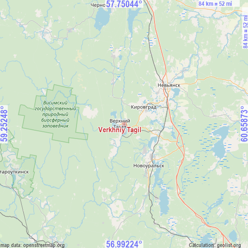
Verkhniy Tagil GPS coordinates[2]
57° 22' 23.88" North, 59° 57' 20.16" East
| Map corner | latitude | longitude |
|---|---|---|
| Upper-left | 57.75044°, | 59.25248° |
| Center: | 57.3733°, | 59.9556° |
| Lower-right: | 56.99224°, | 60.65873° |
| Map W x H: | 84.3×84.3 km | = 52.4×52.4mi |
| max Lat: | 73.50819° ⇑20.6% North |
| Verkhniy Tagil: | 57.3733° |
| min Lat: | ⇓79.4% South 41.28413° |
| min Long | Verkhniy Tagil | max Long |
| -179.12198° | 59.9556° | 179.35046° |
| W 71.5%⇐ | ⇒28.5% E |
Elevation
Elevation of Verkhniy Tagil is 264 m = 866 ft, and this is 61.4 m = 201 ft above average elevation for this country.
| Max E: |
2518 m = 8261 ft | 18.6% |
| Verkhniy Tagil | 264 m 866 ft | |
| Avg. | 202.6 m = 665 ft | |
Min E: |
-28 m = -92 ft | 81.4% |
See also: Russia elevation on elevation.city.
Geographical zone
Verkhniy Tagil is located in North temperate zone (between Tropic of Cancer and the Arctic Circle). Distance of this North polar circle is 1021.9 km =635 mi to North.| Distance of | km | miles | from Verkhniy Tagil |
|---|---|---|---|
| North Pole | 3627.7 | 2254.1 | to North |
| Arctic Circle | 1021.9 | 635 | to North |
| Tropic Cancer | 3773.4 | 2344.7 | to South |
| Equator | 6379.3 | 3963.9 | to South |


Nearby cities:
15 places around Verkhniy Tagil: (largest is in red/bold)
• Ayat’
41.3 km =25.7 mi,  156°
156°
• Chernoistochinsk
40.7 km =25.3 mi,  352°
352°
• Kalinovo
29.2 km =18.1 mi, 156°
• Karpushikha
14.7 km =9.1 mi, 345°
• Kirovgrad
8.8 km =5.5 mi,  44°
44°
• Levikha
23.6 km =14.7 mi, 351°
• Nev’yansk
20.4 km =12.7 mi,  48°
48°
• Neyvo-Rudyanka
11.2 km =7 mi,  106°
106°
• Novoural’sk
16.3 km =10.1 mi,  151°
151°
• Staroutkinsk
40.5 km =25.2 mi,  246°
246°
• Tavatuy
29 km =18 mi, 148°
• Tsementnyy
16 km =9.9 mi, 47°
• Uralets
36.9 km =22.9 mi,  330°
330°
• Verkh-Neyvinskiy
15.8 km =9.8 mi,  136°
136°
• Visim
40.9 km =25.4 mi,  318°
318°
Sources, notices
• [Note1] Compared only with cities in Russia existing in our database
• [Src1] Map data: © OpenStreetMap contributors (CC-BY-SA)
• [Src2] Other city data from geonames.org with taken over terms of usage.
• [Src3] Geographical zone / Annual Mean Temperature by Robert A. Rohde @ Wikipedia
