Staroderevyankovskaya geodata
Staroderevyankovskaya (Krasnodarskiy) is a populated place; located in Russia in Europe/Moscow (GMT+3) time zone. With population of 12,918 people, there are 1212 cities with bigger population in this country. Compared to other cities in Russia, 83.8% of cities are located further ↑North; 72.2% of cities are located further →East and 91.9% of cities have higher elevation than Staroderevyankovskaya. Note1


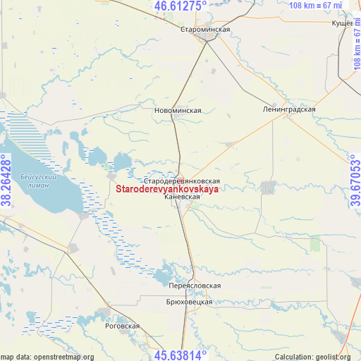
Staroderevyankovskaya GPS coordinates[2]
46° 7' 39.36" North, 38° 58' 2.64" East
| Map corner | latitude | longitude |
|---|---|---|
| Upper-left | 46.61275°, | 38.26428° |
| Center: | 46.1276°, | 38.9674° |
| Lower-right: | 45.63814°, | 39.67053° |
| Map W x H: | 108.4×108.4 km | = 67.4×67.4mi |
| max Lat: | 73.50819° ⇑83.8% North |
| Staroderevyankovskaya: | 46.1276° |
| min Lat: | ⇓16.2% South 41.28413° |
| min Long | Staroderevyanko | max Long |
| -179.12198° | 38.9674° | 179.35046° |
| W 27.8%⇐ | ⇒72.2% E |
Elevation
Elevation of Staroderevyankovskaya is 22 m = 72 ft, and this is 180.6 m = 593 ft below average elevation for this country.
| Max E: |
2518 m = 8261 ft | 91.9% |
| Avg. | 202.6 m = 665 ft | |
| Staroderevyankovskaya | 22 m = 72 ft | |
Min E: |
-28 m = -92 ft | 8.1% |
See also: Russia elevation on elevation.city.
Geographical zone
Staroderevyankovskaya is located in North temperate zone (between Tropic of Cancer and the Arctic Circle). Distance of this North polar circle is 2272.3 km =1411.9 mi to North.| Distance of | km | miles | from Staroderevyankovskaya |
|---|---|---|---|
| North Pole | 4878.2 | 3031.2 | to North |
| Arctic Circle | 2272.3 | 1411.9 | to North |
| Tropic Cancer | 2523 | 1567.7 | to South |
| Equator | 5128.9 | 3186.9 | to South |


Nearby cities:
15 places around Staroderevyankovskaya: (largest is in red/bold)
• Bryukhovetskaya
35.8 km =22.2 mi,  176°
176°
• Chelbasskaya
35.3 km =21.9 mi,  117°
117°
• Kanevskaya
4.8 km =3 mi,  187°
187°
• Kopanskaya
41.1 km =25.5 mi,  293°
293°
• Krylovskaya
26 km =16.2 mi,  94°
94°
• Leningradskaya
38.9 km =24.2 mi,  56°
56°
• Novoderevyankovskaya
27.6 km =17.1 mi,  322°
322°
• Novodzhereliyevskaya
45.5 km =28.3 mi,  210°
210°
• Novominskaya
21 km =13 mi,  358°
358°
• Novoplatnirovskaya
34.9 km =21.7 mi, 93°
• Novoshcherbinovskaya
45.9 km =28.5 mi,  327°
327°
• Ol’ginskaya
38.1 km =23.7 mi,  238°
238°
• Pereyaslovskaya
32.1 km =19.9 mi,  172°
172°
• Rogovskaya
47.5 km =29.5 mi,  201°
201°
• Starominskaya
45.2 km =28.1 mi,  8°
8°
Sources, notices
• [Note1] Compared only with cities in Russia existing in our database
• [Src1] Map data: © OpenStreetMap contributors (CC-BY-SA)
• [Src2] Other city data from geonames.org with taken over terms of usage.
• [Src3] Geographical zone / Annual Mean Temperature by Robert A. Rohde @ Wikipedia
